Kreileroord geodata
Kreileroord (North Holland) is a populated place; located in Netherlands in Europe/Amsterdam (GMT+2) time zone. With population of 585 people, there are 1736 cities with bigger population in this country. Compared to other cities in Netherlands, 80.8% of cities are located further ↓South; 70.8% of cities are located further →East and 99.9% of cities have higher elevation than Kreileroord. Note1


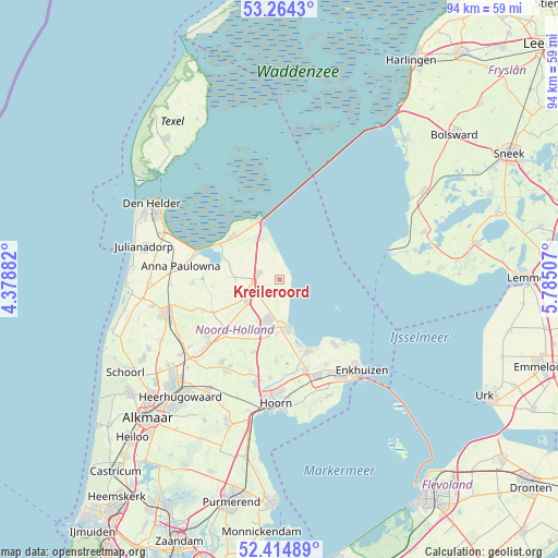
Kreileroord GPS coordinates[2]
52° 50' 30.012" North, 5° 4' 54.984" East
| Map corner | latitude | longitude |
|---|---|---|
| Upper-left | 53.2643°, | 4.37882° |
| Center: | 52.84167°, | 5.08194° |
| Lower-right: | 52.41489°, | 5.78507° |
| Map W x H: | 94.4×94.4 km | = 58.7×58.7mi |
| max Lat: | 53.48025° ⇑19.2% North |
| Kreileroord: | 52.84167° |
| min Lat: | ⇓80.8% South 50.76917° |
| min Long | Kreileroord | max Long |
| 3.38611° | 5.08194° | 7.16528° |
| W 29.2%⇐ | ⇒70.8% E |
Elevation
Elevation of Kreileroord is -4 m = -13 ft, and this is 19 m = 62 ft below average elevation for this country.
| Max E: |
203 m = 666 ft | 99.9% |
| Avg. | 15 m = 49 ft | |
| Kreileroord | -4 m = -13 ft | |
Min E: |
-6 m = -20 ft | 0.1% |
See also: Netherlands elevation on elevation.city.
Geographical zone
Kreileroord is located in North temperate zone (between Tropic of Cancer and the Arctic Circle). Distance of this North polar circle is 1525.7 km =948 mi to North.| Distance of | km | miles | from Kreileroord |
|---|---|---|---|
| North Pole | 4131.6 | 2567.3 | to North |
| Arctic Circle | 1525.7 | 948 | to North |
| Tropic Cancer | 3269.5 | 2031.6 | to South |
| Equator | 5875.4 | 3650.8 | to South |


Nearby cities:
15 places around Kreileroord: (largest is in red/bold)
• Abbekerk
13 km =8.1 mi,  199°
199°
• Bangert
13.5 km =8.4 mi,  150°
150°
• Den Oever
10.8 km =6.7 mi,  341°
341°
• Hippolytushoef
10.9 km =6.8 mi,  312°
312°
• Kolhorn
14 km =8.7 mi,  247°
247°
• Medemblik
7.9 km =4.9 mi,  168°
168°
• Middenmeer
6.8 km =4.2 mi,  235°
235°
• Midwoud
13.9 km =8.6 mi,  181°
181°
• Onderdijk
11.6 km =7.2 mi,  161°
161°
• Oostwoud
12.9 km =8 mi, 178°
• Opperdoes
9.2 km =5.7 mi, 182°
• Slootdorp
7.4 km =4.6 mi,  270°
270°
• Twisk
11.4 km =7.1 mi,  189°
189°
• Westerland
11.8 km =7.3 mi,  299°
299°
• Wieringerwerf
3.9 km =2.4 mi,  285°
285°
Sources, notices
• [Note1] Compared only with cities in Netherlands existing in our database
• [Src1] Map data: © OpenStreetMap contributors (CC-BY-SA)
• [Src2] Other city data from geonames.org with taken over terms of usage.
• [Src3] Geographical zone / Annual Mean Temperature by Robert A. Rohde @ Wikipedia
