Slootdorp geodata
Slootdorp (North Holland) is a populated place; located in Netherlands in Europe/Amsterdam (GMT+2) time zone. With population of 1,350 people, there are 1213 cities with bigger population in this country. Compared to other cities in Netherlands, 80.9% of cities are located further ↓South; 74.2% of cities are located further →East and 96.1% of cities have higher elevation than Slootdorp. Note1


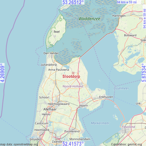
Slootdorp GPS coordinates[2]
52° 50' 33" North, 4° 58' 19.992" East
| Map corner | latitude | longitude |
|---|---|---|
| Upper-left | 53.26512°, | 4.26909° |
| Center: | 52.8425°, | 4.97222° |
| Lower-right: | 52.41573°, | 5.67534° |
| Map W x H: | 94.4×94.4 km | = 58.7×58.7mi |
| max Lat: | 53.48025° ⇑19.1% North |
| Slootdorp: | 52.8425° |
| min Lat: | ⇓80.9% South 50.76917° |
| min Long | Slootdorp | max Long |
| 3.38611° | 4.97222° | 7.16528° |
| W 25.8%⇐ | ⇒74.2% E |
Elevation
Elevation of Slootdorp is -1 m = -3 ft, and this is 16 m = 52 ft below average elevation for this country.
| Max E: |
203 m = 666 ft | 96.1% |
| Avg. | 15 m = 49 ft | |
| Slootdorp | -1 m = -3 ft | |
Min E: |
-6 m = -20 ft | 3.9% |
See also: Netherlands elevation on elevation.city.
Geographical zone
Slootdorp is located in North temperate zone (between Tropic of Cancer and the Arctic Circle). Distance of this North polar circle is 1525.6 km =948 mi to North.| Distance of | km | miles | from Slootdorp |
|---|---|---|---|
| North Pole | 4131.5 | 2567.2 | to North |
| Arctic Circle | 1525.6 | 948 | to North |
| Tropic Cancer | 3269.6 | 2031.6 | to South |
| Equator | 5875.5 | 3650.9 | to South |


Nearby cities:
15 places around Slootdorp: (largest is in red/bold)
• Barsingerhorn
9.7 km =6 mi,  228°
228°
• Den Oever
10.9 km =6.8 mi,  21°
21°
• Hippolytushoef
7.3 km =4.5 mi,  354°
354°
• Kolhorn
7.8 km =4.8 mi, 226°
• Kreileroord
7.4 km =4.6 mi,  90°
90°
• Medemblik
11.9 km =7.4 mi,  131°
131°
• Middenmeer
4.4 km =2.7 mi,  156°
156°
• Nieuwe-Niedorp
12.4 km =7.7 mi,  203°
203°
• Opperdoes
11.6 km =7.2 mi,  143°
143°
• Oudesluis
11 km =6.8 mi,  265°
265°
• Twisk
12.5 km =7.8 mi,  154°
154°
• Westerland
6.4 km =4 mi,  333°
333°
• Wieringerwaard
7.2 km =4.5 mi,  264°
264°
• Wieringerwerf
3.8 km =2.4 mi,  75°
75°
• Winkel
10.9 km =6.8 mi,  205°
205°
Sources, notices
• [Note1] Compared only with cities in Netherlands existing in our database
• [Src1] Map data: © OpenStreetMap contributors (CC-BY-SA)
• [Src2] Other city data from geonames.org with taken over terms of usage.
• [Src3] Geographical zone / Annual Mean Temperature by Robert A. Rohde @ Wikipedia
