Graft geodata
Graft (North Holland) is a populated place; located in Netherlands in Europe/Amsterdam (GMT+2) time zone. With population of 880 people, there are 1476 cities with bigger population in this country. Compared to other cities in Netherlands, 73% of cities are located further ↓South; 78.4% of cities are located further →East and 98.2% of cities have higher elevation than Graft. Note1


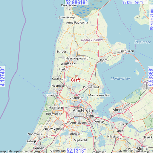
Graft GPS coordinates[2]
52° 33' 38.988" North, 4° 49' 50.016" East
| Map corner | latitude | longitude |
|---|---|---|
| Upper-left | 52.98619°, | 4.12743° |
| Center: | 52.56083°, | 4.83056° |
| Lower-right: | 52.1313°, | 5.53368° |
| Map W x H: | 95.1×95.1 km | = 59.1×59.1mi |
| max Lat: | 53.48025° ⇑27% North |
| Graft: | 52.56083° |
| min Lat: | ⇓73% South 50.76917° |
| min Long | Graft | max Long |
| 3.38611° | 4.83056° | 7.16528° |
| W 21.6%⇐ | ⇒78.4% E |
Elevation
Elevation of Graft is -2 m = -7 ft, and this is 17 m = 56 ft below average elevation for this country.
| Max E: |
203 m = 666 ft | 98.2% |
| Avg. | 15 m = 49 ft | |
| Graft | -2 m = -7 ft | |
Min E: |
-6 m = -20 ft | 1.8% |
See also: Netherlands elevation on elevation.city.
Geographical zone
Graft is located in North temperate zone (between Tropic of Cancer and the Arctic Circle). Distance of this North polar circle is 1557 km =967.5 mi to North.| Distance of | km | miles | from Graft |
|---|---|---|---|
| North Pole | 4162.8 | 2586.6 | to North |
| Arctic Circle | 1557 | 967.5 | to North |
| Tropic Cancer | 3238.3 | 2012.2 | to South |
| Equator | 5844.2 | 3631.4 | to South |


Nearby cities:
15 places around Graft: (largest is in red/bold)
• Alkmaar
9.6 km =6 mi,  324°
324°
• De Rijp
1.1 km =0.7 mi,  114°
114°
• Grootschermer
2.7 km =1.7 mi,  28°
28°
• Halfweg
7.7 km =4.8 mi,  121°
121°
• Langeheit
9.1 km =5.7 mi,  212°
212°
• Limmen
9.2 km =5.7 mi,  275°
275°
• Middenbeemster
5.7 km =3.5 mi,  103°
103°
• Oosterzij
8.9 km =5.5 mi,  287°
287°
• Oostknollendam
5.5 km =3.4 mi, 208°
• Oterleek
8.4 km =5.2 mi,  1°
1°
• Schermerhorn
6.1 km =3.8 mi,  42°
42°
• Stompetoren
5.9 km =3.7 mi,  353°
353°
• Uitgeest
8.9 km =5.5 mi,  246°
246°
• West-Graftdijk
2.5 km =1.6 mi, 252°
• Zuidschermer
4.4 km =2.7 mi,  307°
307°
Sources, notices
• [Note1] Compared only with cities in Netherlands existing in our database
• [Src1] Map data: © OpenStreetMap contributors (CC-BY-SA)
• [Src2] Other city data from geonames.org with taken over terms of usage.
• [Src3] Geographical zone / Annual Mean Temperature by Robert A. Rohde @ Wikipedia
