Zaandijk geodata
Zaandijk (North Holland) is a populated place; located in Netherlands in Europe/Amsterdam (GMT+2) time zone. With population of 9,040 people, there are 315 cities with bigger population in this country. Compared to other cities in Netherlands, 71% of cities are located further ↓South; 79.3% of cities are located further →East and 96.1% of cities have higher elevation than Zaandijk. Note1


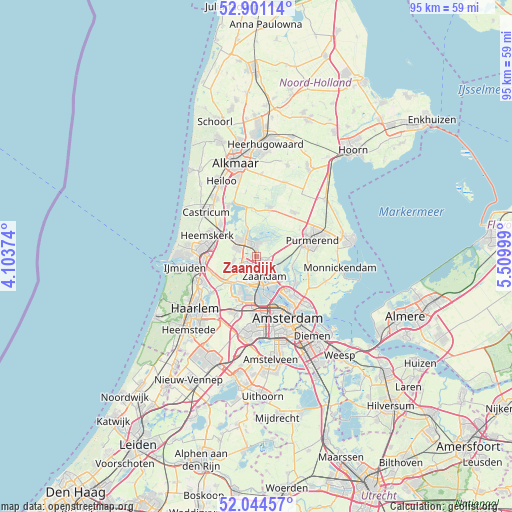
Zaandijk GPS coordinates[2]
52° 28' 29.784" North, 4° 48' 24.696" East
| Map corner | latitude | longitude |
|---|---|---|
| Upper-left | 52.90114°, | 4.10374° |
| Center: | 52.47494°, | 4.80686° |
| Lower-right: | 52.04457°, | 5.50999° |
| Map W x H: | 95.2×95.2 km | = 59.2×59.2mi |
| max Lat: | 53.48025° ⇑29% North |
| Zaandijk: | 52.47494° |
| min Lat: | ⇓71% South 50.76917° |
| min Long | Zaandijk | max Long |
| 3.38611° | 4.80686° | 7.16528° |
| W 20.7%⇐ | ⇒79.3% E |
Elevation
Elevation of Zaandijk is -1 m = -3 ft, and this is 16 m = 52 ft below average elevation for this country.
| Max E: |
203 m = 666 ft | 96.1% |
| Avg. | 15 m = 49 ft | |
| Zaandijk | -1 m = -3 ft | |
Min E: |
-6 m = -20 ft | 3.9% |
See also: Netherlands elevation on elevation.city.
Geographical zone
Zaandijk is located in North temperate zone (between Tropic of Cancer and the Arctic Circle). Distance of this North polar circle is 1566.5 km =973.4 mi to North.| Distance of | km | miles | from Zaandijk |
|---|---|---|---|
| North Pole | 4172.4 | 2592.6 | to North |
| Arctic Circle | 1566.5 | 973.4 | to North |
| Tropic Cancer | 3228.7 | 2006.2 | to South |
| Equator | 5834.7 | 3625.5 | to South |


Nearby cities:
15 places around Zaandijk: (largest is in red/bold)
• De Maer
9.8 km =6.1 mi,  300°
300°
• De Rijp
9.5 km =5.9 mi,  16°
16°
• Den Ilp
7.2 km =4.5 mi,  108°
108°
• Graft
9.7 km =6 mi,  9°
9°
• Halfweg
9.8 km =6.1 mi,  56°
56°
• Heemskerk
10 km =6.2 mi,  293°
293°
• Ilpendam
9.8 km =6.1 mi,  97°
97°
• Kadoelen
9.3 km =5.8 mi,  133°
133°
• Landsmeer
8.8 km =5.5 mi,  123°
123°
• Langeheit
3.8 km =2.4 mi, 300°
• Oostknollendam
4.8 km =3 mi,  347°
347°
• Uitgeest
8.9 km =5.5 mi,  312°
312°
• West-Graftdijk
8.8 km =5.5 mi,  355°
355°
• Zaandam
4.3 km =2.7 mi,  161°
161°
• Zaanstad
2.5 km =1.6 mi,  169°
169°
Sources, notices
• [Note1] Compared only with cities in Netherlands existing in our database
• [Src1] Map data: © OpenStreetMap contributors (CC-BY-SA)
• [Src2] Other city data from geonames.org with taken over terms of usage.
• [Src3] Geographical zone / Annual Mean Temperature by Robert A. Rohde @ Wikipedia
