Stompetoren geodata
Stompetoren (North Holland) is a populated place; located in Netherlands in Europe/Amsterdam (GMT+2) time zone. With population of 1,920 people, there are 989 cities with bigger population in this country. Compared to other cities in Netherlands, 74% of cities are located further ↓South; 78.8% of cities are located further →East and 96.1% of cities have higher elevation than Stompetoren. Note1


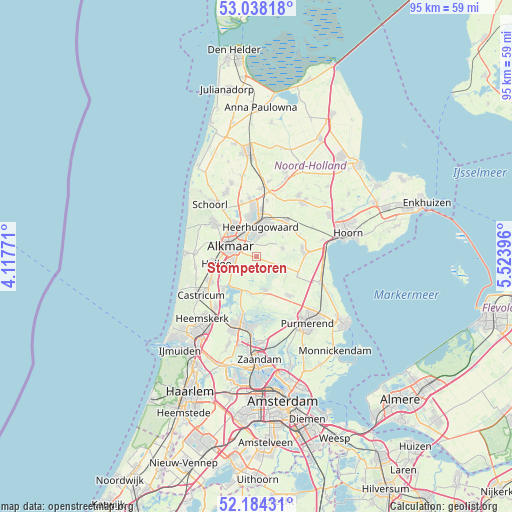
Stompetoren GPS coordinates[2]
52° 36' 47.988" North, 4° 49' 14.988" East
| Map corner | latitude | longitude |
|---|---|---|
| Upper-left | 53.03818°, | 4.11771° |
| Center: | 52.61333°, | 4.82083° |
| Lower-right: | 52.18431°, | 5.52396° |
| Map W x H: | 94.9×94.9 km | = 59×59mi |
| max Lat: | 53.48025° ⇑26% North |
| Stompetoren: | 52.61333° |
| min Lat: | ⇓74% South 50.76917° |
| min Long | Stompetoren | max Long |
| 3.38611° | 4.82083° | 7.16528° |
| W 21.2%⇐ | ⇒78.8% E |
Elevation
Elevation of Stompetoren is -1 m = -3 ft, and this is 16 m = 52 ft below average elevation for this country.
| Max E: |
203 m = 666 ft | 96.1% |
| Avg. | 15 m = 49 ft | |
| Stompetoren | -1 m = -3 ft | |
Min E: |
-6 m = -20 ft | 3.9% |
See also: Netherlands elevation on elevation.city.
Geographical zone
Stompetoren is located in North temperate zone (between Tropic of Cancer and the Arctic Circle). Distance of this North polar circle is 1551.1 km =963.8 mi to North.| Distance of | km | miles | from Stompetoren |
|---|---|---|---|
| North Pole | 4157 | 2583 | to North |
| Arctic Circle | 1551.1 | 963.8 | to North |
| Tropic Cancer | 3244.1 | 2015.8 | to South |
| Equator | 5850.1 | 3635.1 | to South |


Nearby cities:
15 places around Stompetoren: (largest is in red/bold)
• Alkmaar
5.3 km =3.3 mi,  292°
292°
• Broek op Langedijk
6.8 km =4.2 mi,  351°
351°
• De Goorn
8.6 km =5.3 mi,  80°
80°
• De Rijp
6.5 km =4 mi,  164°
164°
• Graft
5.9 km =3.7 mi,  173°
173°
• Grootschermer
4 km =2.5 mi,  150°
150°
• Heerhugowaard
6.7 km =4.2 mi,  16°
16°
• Hensbroek
6.6 km =4.1 mi,  40°
40°
• Oosterzij
8.4 km =5.2 mi,  247°
247°
• Oterleek
2.8 km =1.7 mi, 19°
• Schermerhorn
5 km =3.1 mi,  106°
106°
• Sint Pancras
5.8 km =3.6 mi,  334°
334°
• West-Graftdijk
6.8 km =4.2 mi,  194°
194°
• Zuid-Scharwoude
8.2 km =5.1 mi, 354°
• Zuidschermer
4.2 km =2.6 mi,  221°
221°
Sources, notices
• [Note1] Compared only with cities in Netherlands existing in our database
• [Src1] Map data: © OpenStreetMap contributors (CC-BY-SA)
• [Src2] Other city data from geonames.org with taken over terms of usage.
• [Src3] Geographical zone / Annual Mean Temperature by Robert A. Rohde @ Wikipedia
