Schagerbrug geodata
Schagerbrug (North Holland) is a populated place; located in Netherlands in Europe/Amsterdam (GMT+2) time zone. With population of 1,965 people, there are 970 cities with bigger population in this country. Compared to other cities in Netherlands, 80% of cities are located further ↓South; 81.5% of cities are located further →East and 74.9% of cities have higher elevation than Schagerbrug. Note1


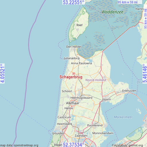
Schagerbrug GPS coordinates[2]
52° 48' 9" North, 4° 45' 29.988" East
| Map corner | latitude | longitude |
|---|---|---|
| Upper-left | 53.22551°, | 4.05521° |
| Center: | 52.8025°, | 4.75833° |
| Lower-right: | 52.37534°, | 5.46146° |
| Map W x H: | 94.5×94.5 km | = 58.7×58.7mi |
| max Lat: | 53.48025° ⇑20% North |
| Schagerbrug: | 52.8025° |
| min Lat: | ⇓80% South 50.76917° |
| min Long | Schagerbrug | max Long |
| 3.38611° | 4.75833° | 7.16528° |
| W 18.5%⇐ | ⇒81.5% E |
Elevation
Elevation of Schagerbrug is 2 m = 7 ft, and this is 13 m = 43 ft below average elevation for this country.
| Max E: |
203 m = 666 ft | 74.9% |
| Avg. | 15 m = 49 ft | |
| Schagerbrug | 2 m = 7 ft | |
Min E: |
-6 m = -20 ft | 25.1% |
See also: Netherlands elevation on elevation.city.
Geographical zone
Schagerbrug is located in North temperate zone (between Tropic of Cancer and the Arctic Circle). Distance of this North polar circle is 1530.1 km =950.8 mi to North.| Distance of | km | miles | from Schagerbrug |
|---|---|---|---|
| North Pole | 4136 | 2570 | to North |
| Arctic Circle | 1530.1 | 950.8 | to North |
| Tropic Cancer | 3265.2 | 2028.9 | to South |
| Equator | 5871.1 | 3648.1 | to South |


Nearby cities:
15 places around Schagerbrug: (largest is in red/bold)
• 't Zand
3.8 km =2.4 mi,  357°
357°
• Barsingerhorn
7.4 km =4.6 mi,  105°
105°
• Burgerbrug
7.1 km =4.4 mi,  211°
211°
• Callantsoog
5.9 km =3.7 mi,  314°
314°
• Dirkshorn
5.9 km =3.7 mi,  169°
169°
• Harenkarspel
7.7 km =4.8 mi, 170°
• Kolhorn
8.8 km =5.5 mi,  96°
96°
• Oudesluis
4.9 km =3 mi,  43°
43°
• Petten
7.7 km =4.8 mi,  238°
238°
• Schagen
3.2 km =2 mi,  121°
121°
• Sint Maarten
3.4 km =2.1 mi,  194°
194°
• Sint Maartensbrug
3.2 km =2 mi,  220°
220°
• Sint Maartensvlotbrug
3.8 km =2.4 mi, 242°
• Waarland
9.8 km =6.1 mi,  149°
149°
• Wieringerwaard
8.1 km =5 mi,  62°
62°
Sources, notices
• [Note1] Compared only with cities in Netherlands existing in our database
• [Src1] Map data: © OpenStreetMap contributors (CC-BY-SA)
• [Src2] Other city data from geonames.org with taken over terms of usage.
• [Src3] Geographical zone / Annual Mean Temperature by Robert A. Rohde @ Wikipedia
