Dirkshorn geodata
Dirkshorn (North Holland) is a populated place; located in Netherlands in Europe/Amsterdam (GMT+2) time zone. With population of 1,480 people, there are 1144 cities with bigger population in this country. Compared to other cities in Netherlands, 78.3% of cities are located further ↓South; 81% of cities are located further →East and 74.9% of cities have higher elevation than Dirkshorn. Note1


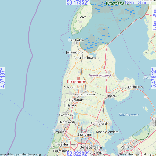
Dirkshorn GPS coordinates[2]
52° 45' 0" North, 4° 46' 30" East
| Map corner | latitude | longitude |
|---|---|---|
| Upper-left | 53.17352°, | 4.07187° |
| Center: | 52.75°, | 4.775° |
| Lower-right: | 52.32232°, | 5.47812° |
| Map W x H: | 94.6×94.6 km | = 58.8×58.8mi |
| max Lat: | 53.48025° ⇑21.7% North |
| Dirkshorn: | 52.75° |
| min Lat: | ⇓78.3% South 50.76917° |
| min Long | Dirkshorn | max Long |
| 3.38611° | 4.775° | 7.16528° |
| W 19%⇐ | ⇒81% E |
Elevation
Elevation of Dirkshorn is 2 m = 7 ft, and this is 13 m = 43 ft below average elevation for this country.
| Max E: |
203 m = 666 ft | 74.9% |
| Avg. | 15 m = 49 ft | |
| Dirkshorn | 2 m = 7 ft | |
Min E: |
-6 m = -20 ft | 25.1% |
See also: Netherlands elevation on elevation.city.
Geographical zone
Dirkshorn is located in North temperate zone (between Tropic of Cancer and the Arctic Circle). Distance of this North polar circle is 1535.9 km =954.4 mi to North.| Distance of | km | miles | from Dirkshorn |
|---|---|---|---|
| North Pole | 4141.8 | 2573.6 | to North |
| Arctic Circle | 1535.9 | 954.4 | to North |
| Tropic Cancer | 3259.3 | 2025.2 | to South |
| Equator | 5865.3 | 3644.5 | to South |


Nearby cities:
15 places around Dirkshorn: (largest is in red/bold)
• Aagtdorp
8.2 km =5.1 mi,  215°
215°
• Barsingerhorn
7.1 km =4.4 mi,  56°
56°
• Burgerbrug
4.9 km =3 mi,  267°
267°
• De Noord
7 km =4.3 mi,  132°
132°
• Harenkarspel
1.8 km =1.1 mi,  176°
176°
• Noord-Scharwoude
6.2 km =3.9 mi,  157°
157°
• Oudkarspel
4.3 km =2.7 mi,  151°
151°
• Petten
7.9 km =4.9 mi,  283°
283°
• Schagen
4.5 km =2.8 mi,  20°
20°
• Schagerbrug
5.9 km =3.7 mi,  349°
349°
• Sint Maarten
3.2 km =2 mi,  321°
321°
• Sint Maartensbrug
4.7 km =2.9 mi, 317°
• Sint Maartensvlotbrug
6.1 km =3.8 mi,  312°
312°
• Waarland
4.6 km =2.9 mi,  124°
124°
• Zuid-Scharwoude
7.4 km =4.6 mi, 162°
Sources, notices
• [Note1] Compared only with cities in Netherlands existing in our database
• [Src1] Map data: © OpenStreetMap contributors (CC-BY-SA)
• [Src2] Other city data from geonames.org with taken over terms of usage.
• [Src3] Geographical zone / Annual Mean Temperature by Robert A. Rohde @ Wikipedia
