Harenkarspel geodata
Harenkarspel (North Holland) is a populated place; located in Netherlands in Europe/Amsterdam (GMT+2) time zone. With population of 15,941 people, there are 219 cities with bigger population in this country. Compared to other cities in Netherlands, 77.8% of cities are located further ↓South; 80.7% of cities are located further →East and 99.2% of cities have higher elevation than Harenkarspel. Note1


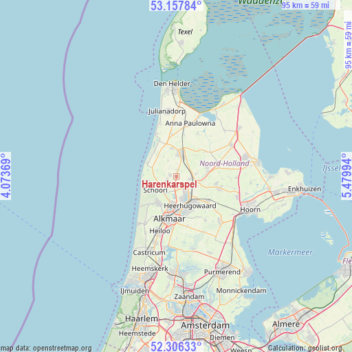
Harenkarspel GPS coordinates[2]
52° 44' 2.976" North, 4° 46' 36.552" East
| Map corner | latitude | longitude |
|---|---|---|
| Upper-left | 53.15784°, | 4.07369° |
| Center: | 52.73416°, | 4.77682° |
| Lower-right: | 52.30633°, | 5.47994° |
| Map W x H: | 94.7×94.7 km | = 58.8×58.8mi |
| max Lat: | 53.48025° ⇑22.2% North |
| Harenkarspel: | 52.73416° |
| min Lat: | ⇓77.8% South 50.76917° |
| min Long | Harenkarspel | max Long |
| 3.38611° | 4.77682° | 7.16528° |
| W 19.3%⇐ | ⇒80.7% E |
Elevation
Elevation of Harenkarspel is -3 m = -10 ft, and this is 18 m = 59 ft below average elevation for this country.
| Max E: |
203 m = 666 ft | 99.2% |
| Avg. | 15 m = 49 ft | |
| Harenkarspel | -3 m = -10 ft | |
Min E: |
-6 m = -20 ft | 0.8% |
See also: Netherlands elevation on elevation.city.
Geographical zone
Harenkarspel is located in North temperate zone (between Tropic of Cancer and the Arctic Circle). Distance of this North polar circle is 1537.7 km =955.5 mi to North.| Distance of | km | miles | from Harenkarspel |
|---|---|---|---|
| North Pole | 4143.6 | 2574.7 | to North |
| Arctic Circle | 1537.7 | 955.5 | to North |
| Tropic Cancer | 3257.6 | 2024.2 | to South |
| Equator | 5863.5 | 3643.4 | to South |


Nearby cities:
15 places around Harenkarspel: (largest is in red/bold)
• Aagtdorp
6.9 km =4.3 mi,  224°
224°
• Barsingerhorn
8.1 km =5 mi,  46°
46°
• Broek op Langedijk
6.9 km =4.3 mi,  163°
163°
• Burgerbrug
5.2 km =3.2 mi,  287°
287°
• De Noord
5.8 km =3.6 mi,  120°
120°
• Dirkshorn
1.8 km =1.1 mi,  356°
356°
• Noord-Scharwoude
4.6 km =2.9 mi,  149°
149°
• Oudkarspel
2.8 km =1.7 mi,  136°
136°
• Schagen
6.1 km =3.8 mi,  13°
13°
• Schagerbrug
7.7 km =4.8 mi,  350°
350°
• Sint Maarten
4.7 km =2.9 mi,  333°
333°
• Sint Maartensbrug
6.1 km =3.8 mi, 327°
• Sint Maartensvlotbrug
7.4 km =4.6 mi,  321°
321°
• Waarland
3.8 km =2.4 mi,  102°
102°
• Zuid-Scharwoude
5.7 km =3.5 mi, 158°
Sources, notices
• [Note1] Compared only with cities in Netherlands existing in our database
• [Src1] Map data: © OpenStreetMap contributors (CC-BY-SA)
• [Src2] Other city data from geonames.org with taken over terms of usage.
• [Src3] Geographical zone / Annual Mean Temperature by Robert A. Rohde @ Wikipedia
