Waarland geodata
Waarland (North Holland) is a populated place; located in Netherlands in Europe/Amsterdam (GMT+2) time zone. With population of 1,970 people, there are 969 cities with bigger population in this country. Compared to other cities in Netherlands, 77.5% of cities are located further ↓South; 78.3% of cities are located further →East and 96.1% of cities have higher elevation than Waarland. Note1


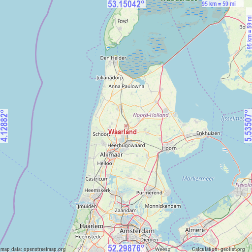
Waarland GPS coordinates[2]
52° 43' 36.012" North, 4° 49' 54.984" East
| Map corner | latitude | longitude |
|---|---|---|
| Upper-left | 53.15042°, | 4.12882° |
| Center: | 52.72667°, | 4.83194° |
| Lower-right: | 52.29876°, | 5.53507° |
| Map W x H: | 94.7×94.7 km | = 58.8×58.8mi |
| max Lat: | 53.48025° ⇑22.5% North |
| Waarland: | 52.72667° |
| min Lat: | ⇓77.5% South 50.76917° |
| min Long | Waarland | max Long |
| 3.38611° | 4.83194° | 7.16528° |
| W 21.7%⇐ | ⇒78.3% E |
Elevation
Elevation of Waarland is -1 m = -3 ft, and this is 16 m = 52 ft below average elevation for this country.
| Max E: |
203 m = 666 ft | 96.1% |
| Avg. | 15 m = 49 ft | |
| Waarland | -1 m = -3 ft | |
Min E: |
-6 m = -20 ft | 3.9% |
See also: Netherlands elevation on elevation.city.
Geographical zone
Waarland is located in North temperate zone (between Tropic of Cancer and the Arctic Circle). Distance of this North polar circle is 1538.5 km =956 mi to North.| Distance of | km | miles | from Waarland |
|---|---|---|---|
| North Pole | 4144.4 | 2575.2 | to North |
| Arctic Circle | 1538.5 | 956 | to North |
| Tropic Cancer | 3256.7 | 2023.6 | to South |
| Equator | 5862.7 | 3642.9 | to South |


Nearby cities:
15 places around Waarland: (largest is in red/bold)
• Barsingerhorn
6.8 km =4.2 mi,  18°
18°
• Broek op Langedijk
6.1 km =3.8 mi,  196°
196°
• De Noord
2.5 km =1.6 mi,  148°
148°
• Dirkshorn
4.6 km =2.9 mi,  304°
304°
• Harenkarspel
3.8 km =2.4 mi,  282°
282°
• Heerhugowaard
6.2 km =3.9 mi,  169°
169°
• Hoogwoud
7.3 km =4.5 mi,  99°
99°
• Nieuwe-Niedorp
4.7 km =2.9 mi,  71°
71°
• Noord-Scharwoude
3.4 km =2.1 mi, 204°
• Obdam
7.6 km =4.7 mi,  138°
138°
• Oudkarspel
2.1 km =1.3 mi,  235°
235°
• Schagen
7.1 km =4.4 mi,  341°
341°
• Sint Maarten
7.7 km =4.8 mi,  311°
311°
• Winkel
5.7 km =3.5 mi,  57°
57°
• Zuid-Scharwoude
4.7 km =2.9 mi, 199°
Sources, notices
• [Note1] Compared only with cities in Netherlands existing in our database
• [Src1] Map data: © OpenStreetMap contributors (CC-BY-SA)
• [Src2] Other city data from geonames.org with taken over terms of usage.
• [Src3] Geographical zone / Annual Mean Temperature by Robert A. Rohde @ Wikipedia
