Schagen geodata
Schagen (North Holland) is a populated place; located in Netherlands in Europe/Amsterdam (GMT+2) time zone. With population of 5,910 people, there are 418 cities with bigger population in this country. Compared to other cities in Netherlands, 79.4% of cities are located further ↓South; 79.7% of cities are located further →East and 65.8% of cities have higher elevation than Schagen. Note1


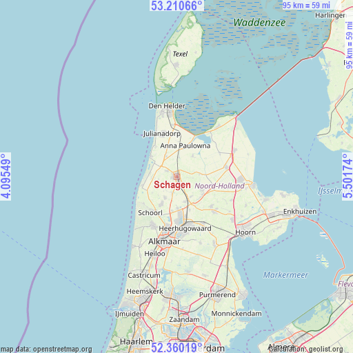
Schagen GPS coordinates[2]
52° 47' 15" North, 4° 47' 54.996" East
| Map corner | latitude | longitude |
|---|---|---|
| Upper-left | 53.21066°, | 4.09549° |
| Center: | 52.7875°, | 4.79861° |
| Lower-right: | 52.36019°, | 5.50174° |
| Map W x H: | 94.6×94.6 km | = 58.8×58.8mi |
| max Lat: | 53.48025° ⇑20.6% North |
| Schagen: | 52.7875° |
| min Lat: | ⇓79.4% South 50.76917° |
| min Long | Schagen | max Long |
| 3.38611° | 4.79861° | 7.16528° |
| W 20.3%⇐ | ⇒79.7% E |
Elevation
Elevation of Schagen is 3 m = 10 ft, and this is 12 m = 39 ft below average elevation for this country.
| Max E: |
203 m = 666 ft | 65.8% |
| Avg. | 15 m = 49 ft | |
| Schagen | 3 m = 10 ft | |
Min E: |
-6 m = -20 ft | 34.2% |
See also: Netherlands elevation on elevation.city.
Geographical zone
Schagen is located in North temperate zone (between Tropic of Cancer and the Arctic Circle). Distance of this North polar circle is 1531.8 km =951.8 mi to North.| Distance of | km | miles | from Schagen |
|---|---|---|---|
| North Pole | 4137.6 | 2571 | to North |
| Arctic Circle | 1531.8 | 951.8 | to North |
| Tropic Cancer | 3263.5 | 2027.8 | to South |
| Equator | 5869.4 | 3647.1 | to South |


Nearby cities:
15 places around Schagen: (largest is in red/bold)
• 't Zand
6.2 km =3.9 mi,  332°
332°
• Barsingerhorn
4.4 km =2.7 mi,  93°
93°
• Burgerbrug
7.8 km =4.8 mi,  235°
235°
• Dirkshorn
4.5 km =2.8 mi,  200°
200°
• Harenkarspel
6.1 km =3.8 mi,  193°
193°
• Kolhorn
6.1 km =3.8 mi,  83°
83°
• Oudesluis
5.2 km =3.2 mi,  7°
7°
• Oudkarspel
8 km =5 mi,  176°
176°
• Schagerbrug
3.2 km =2 mi,  301°
301°
• Sint Maarten
3.9 km =2.4 mi, 244°
• Sint Maartensbrug
4.8 km =3 mi,  261°
261°
• Sint Maartensvlotbrug
6.1 km =3.8 mi,  269°
269°
• Waarland
7.1 km =4.4 mi,  161°
161°
• Wieringerwaard
7 km =4.3 mi,  39°
39°
• Winkel
7.9 km =4.9 mi,  117°
117°
Sources, notices
• [Note1] Compared only with cities in Netherlands existing in our database
• [Src1] Map data: © OpenStreetMap contributors (CC-BY-SA)
• [Src2] Other city data from geonames.org with taken over terms of usage.
• [Src3] Geographical zone / Annual Mean Temperature by Robert A. Rohde @ Wikipedia
