Hengelo geodata
Hengelo (Gelderland) is a populated place; located in Netherlands in Europe/Amsterdam (GMT+1) time zone. With population of 4,510 people, there are 532 cities with bigger population in this country. Compared to other cities in Netherlands, 51.7% of cities are located further ↓South; 85.8% of cities are located further ←West and 72.5% of cities have lower elevation than Hengelo. Note1


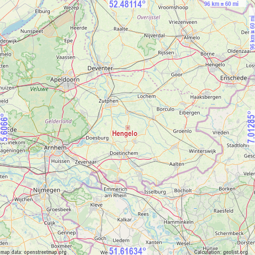
Hengelo GPS coordinates[2]
52° 3' 2.988" North, 6° 18' 34.992" East
| Map corner | latitude | longitude |
|---|---|---|
| Upper-left | 52.48114°, | 5.6066° |
| Center: | 52.05083°, | 6.30972° |
| Lower-right: | 51.61634°, | 7.01285° |
| Map W x H: | 96.2×96.2 km | = 59.8×59.8mi |
| max Lat: | 53.48025° ⇑48.3% North |
| Hengelo: | 52.05083° |
| min Lat: | ⇓51.7% South 50.76917° |
| min Long | Hengelo | max Long |
| 3.38611° | 6.30972° | 7.16528° |
| W 85.8%⇐ | ⇒14.2% E |
Elevation
Elevation of Hengelo is 16 m = 52 ft, and this is 1 m = 3 ft above average elevation for this country.
| Max E: |
203 m = 666 ft | 27.5% |
| Hengelo | 16 m 52 ft | |
| Avg. | 15 m = 49 ft | |
Min E: |
-6 m = -20 ft | 72.5% |
See also: Netherlands elevation on elevation.city.
Geographical zone
Hengelo is located in North temperate zone (between Tropic of Cancer and the Arctic Circle). Distance of this North polar circle is 1613.7 km =1002.7 mi to North.| Distance of | km | miles | from Hengelo |
|---|---|---|---|
| North Pole | 4219.6 | 2621.9 | to North |
| Arctic Circle | 1613.7 | 1002.7 | to North |
| Tropic Cancer | 3181.6 | 1977 | to South |
| Equator | 5787.5 | 3596.2 | to South |


Nearby cities:
15 places around Hengelo: (largest is in red/bold)
• Baak
6.3 km =3.9 mi,  297°
297°
• Brummen
11.4 km =7.1 mi,  292°
292°
• Doetinchem
9.6 km =6 mi,  188°
188°
• Drempt
10.4 km =6.5 mi,  242°
242°
• Halle
10.7 km =6.6 mi,  129°
129°
• Hummelo
7.4 km =4.6 mi,  225°
225°
• Keijenborg
2.6 km =1.6 mi,  203°
203°
• Leesten
10.1 km =6.3 mi,  328°
328°
• Ooyerhoek
10.5 km =6.5 mi, 325°
• Ruurlo
10.5 km =6.5 mi,  66°
66°
• Steenderen
8.5 km =5.3 mi,  280°
280°
• Vorden
6 km =3.7 mi,  0°
0°
• Warken
10.3 km =6.4 mi,  343°
343°
• Warnsveld
11.1 km =6.9 mi, 330°
• Zelhem
5.6 km =3.5 mi,  151°
151°
Sources, notices
• [Note1] Compared only with cities in Netherlands existing in our database
• [Src1] Map data: © OpenStreetMap contributors (CC-BY-SA)
• [Src2] Other city data from geonames.org with taken over terms of usage.
• [Src3] Geographical zone / Annual Mean Temperature by Robert A. Rohde @ Wikipedia
