Nunspeet geodata
Nunspeet (Gelderland) is a populated place; located in Netherlands in Europe/Amsterdam (GMT+2) time zone. With population of 19,496 people, there are 180 cities with bigger population in this country. Compared to other cities in Netherlands, 68.6% of cities are located further ↓South; 56.8% of cities are located further ←West and 59.4% of cities have lower elevation than Nunspeet. Note1


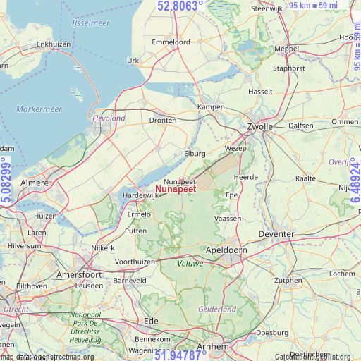
Nunspeet GPS coordinates[2]
52° 22' 45.012" North, 5° 47' 9.996" East
| Map corner | latitude | longitude |
|---|---|---|
| Upper-left | 52.8063°, | 5.08299° |
| Center: | 52.37917°, | 5.78611° |
| Lower-right: | 51.94787°, | 6.48924° |
| Map W x H: | 95.4×95.4 km | = 59.3×59.3mi |
| max Lat: | 53.48025° ⇑31.4% North |
| Nunspeet: | 52.37917° |
| min Lat: | ⇓68.6% South 50.76917° |
| min Long | Nunspeet | max Long |
| 3.38611° | 5.78611° | 7.16528° |
| W 56.8%⇐ | ⇒43.2% E |
Elevation
Elevation of Nunspeet is 10 m = 33 ft, and this is 5 m = 16 ft below average elevation for this country.
| Max E: |
203 m = 666 ft | 40.6% |
| Avg. | 15 m = 49 ft | |
| Nunspeet | 10 m = 33 ft | |
Min E: |
-6 m = -20 ft | 59.4% |
See also: Netherlands elevation on elevation.city.
Geographical zone
Nunspeet is located in North temperate zone (between Tropic of Cancer and the Arctic Circle). Distance of this North polar circle is 1577.2 km =980 mi to North.| Distance of | km | miles | from Nunspeet |
|---|---|---|---|
| North Pole | 4183 | 2599.2 | to North |
| Arctic Circle | 1577.2 | 980 | to North |
| Tropic Cancer | 3218.1 | 1999.6 | to South |
| Equator | 5824 | 3618.9 | to South |


Nearby cities:
15 places around Nunspeet: (largest is in red/bold)
• Biddinghuizen
10.5 km =6.5 mi,  323°
323°
• Broekdijk
12.7 km =7.9 mi,  51°
51°
• Doornspijk
4.9 km =3 mi,  26°
26°
• Elburg
8.5 km =5.3 mi, 26°
• Elspeet
9.7 km =6 mi,  178°
178°
• Emst
14.6 km =9.1 mi,  118°
118°
• Epe
13.8 km =8.6 mi,  104°
104°
• Ermelo
14.3 km =8.9 mi,  231°
231°
• Harderwijk
12 km =7.5 mi,  249°
249°
• Hoge Enk
6.8 km =4.2 mi, 33°
• Hulshorst
4.1 km =2.5 mi,  244°
244°
• Oldebroek
10.7 km =6.6 mi, 46°
• Oostendorp
8.9 km =5.5 mi, 31°
• Oosterwolde
12 km =7.5 mi,  36°
36°
• Uddel
13.3 km =8.3 mi, 181°
Sources, notices
• [Note1] Compared only with cities in Netherlands existing in our database
• [Src1] Map data: © OpenStreetMap contributors (CC-BY-SA)
• [Src2] Other city data from geonames.org with taken over terms of usage.
• [Src3] Geographical zone / Annual Mean Temperature by Robert A. Rohde @ Wikipedia
