Nederwoud geodata
Nederwoud (Gelderland) is a populated place; located in Netherlands in Europe/Amsterdam (GMT+2) time zone. With population of 1,610 people, there are 1073 cities with bigger population in this country. Compared to other cities in Netherlands, 54.7% of cities are located further ↓South; 53.7% of cities are located further →East and 59.4% of cities have lower elevation than Nederwoud. Note1


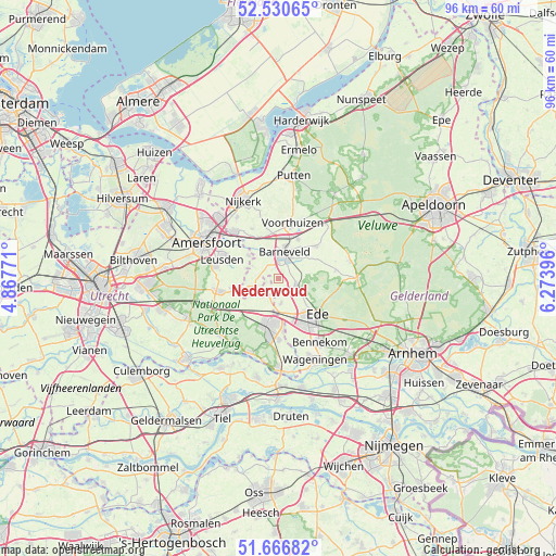
Nederwoud GPS coordinates[2]
52° 6' 2.988" North, 5° 34' 14.988" East
| Map corner | latitude | longitude |
|---|---|---|
| Upper-left | 52.53065°, | 4.86771° |
| Center: | 52.10083°, | 5.57083° |
| Lower-right: | 51.66682°, | 6.27396° |
| Map W x H: | 96×96 km | = 59.7×59.7mi |
| max Lat: | 53.48025° ⇑45.3% North |
| Nederwoud: | 52.10083° |
| min Lat: | ⇓54.7% South 50.76917° |
| min Long | Nederwoud | max Long |
| 3.38611° | 5.57083° | 7.16528° |
| W 46.3%⇐ | ⇒53.7% E |
Elevation
Elevation of Nederwoud is 10 m = 33 ft, and this is 5 m = 16 ft below average elevation for this country.
| Max E: |
203 m = 666 ft | 40.6% |
| Avg. | 15 m = 49 ft | |
| Nederwoud | 10 m = 33 ft | |
Min E: |
-6 m = -20 ft | 59.4% |
See also: Netherlands elevation on elevation.city.
Geographical zone
Nederwoud is located in North temperate zone (between Tropic of Cancer and the Arctic Circle). Distance of this North polar circle is 1608.1 km =999.2 mi to North.| Distance of | km | miles | from Nederwoud |
|---|---|---|---|
| North Pole | 4214 | 2618.5 | to North |
| Arctic Circle | 1608.1 | 999.2 | to North |
| Tropic Cancer | 3187.2 | 1980.4 | to South |
| Equator | 5793.1 | 3599.7 | to South |


Nearby cities:
15 places around Nederwoud: (largest is in red/bold)
• Barneveld
4.5 km =2.8 mi,  12°
12°
• De Klomp
6 km =3.7 mi,  178°
178°
• Doesburg
4.9 km =3 mi,  140°
140°
• Ede
9.6 km =6 mi, 141°
• Ederveen
4.2 km =2.6 mi,  173°
173°
• Kootwijkerbroek
8.7 km =5.4 mi,  50°
50°
• Lunteren
3.9 km =2.4 mi,  116°
116°
• Overberg
8.5 km =5.3 mi,  217°
217°
• Renswoude
3.7 km =2.3 mi,  214°
214°
• Scherpenzeel
6.1 km =3.8 mi,  247°
247°
• Terschuur
8 km =5 mi,  332°
332°
• Veenendaal
8.1 km =5 mi,  185°
185°
• Voorthuizen
9.8 km =6.1 mi, 13°
• Wekerom
9.9 km =6.2 mi,  82°
82°
• Zwartebroek
9.8 km =6.1 mi, 332°
Sources, notices
• [Note1] Compared only with cities in Netherlands existing in our database
• [Src1] Map data: © OpenStreetMap contributors (CC-BY-SA)
• [Src2] Other city data from geonames.org with taken over terms of usage.
• [Src3] Geographical zone / Annual Mean Temperature by Robert A. Rohde @ Wikipedia
