Voorthuizen geodata
Voorthuizen (Gelderland) is a populated place; located in Netherlands in Europe/Amsterdam (GMT+2) time zone. With population of 9,710 people, there are 297 cities with bigger population in this country. Compared to other cities in Netherlands, 59% of cities are located further ↓South; 52.4% of cities are located further →East and 70.6% of cities have lower elevation than Voorthuizen. Note1


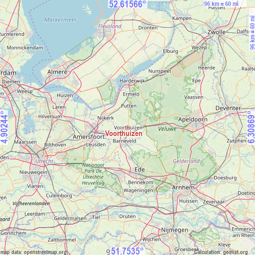
Voorthuizen GPS coordinates[2]
52° 11' 12.012" North, 5° 36' 20.016" East
| Map corner | latitude | longitude |
|---|---|---|
| Upper-left | 52.61566°, | 4.90244° |
| Center: | 52.18667°, | 5.60556° |
| Lower-right: | 51.7535°, | 6.30869° |
| Map W x H: | 95.9×95.9 km | = 59.6×59.6mi |
| max Lat: | 53.48025° ⇑41% North |
| Voorthuizen: | 52.18667° |
| min Lat: | ⇓59% South 50.76917° |
| min Long | Voorthuizen | max Long |
| 3.38611° | 5.60556° | 7.16528° |
| W 47.6%⇐ | ⇒52.4% E |
Elevation
Elevation of Voorthuizen is 15 m = 49 ft, and this is 0 m = 0 ft above average elevation for this country.
| Max E: |
203 m = 666 ft | 29.4% |
| Voorthuizen | 15 m 49 ft | |
| Avg. | 15 m = 49 ft | |
Min E: |
-6 m = -20 ft | 70.6% |
See also: Netherlands elevation on elevation.city.
Geographical zone
Voorthuizen is located in North temperate zone (between Tropic of Cancer and the Arctic Circle). Distance of this North polar circle is 1598.6 km =993.3 mi to North.| Distance of | km | miles | from Voorthuizen |
|---|---|---|---|
| North Pole | 4204.4 | 2612.5 | to North |
| Arctic Circle | 1598.6 | 993.3 | to North |
| Tropic Cancer | 3196.7 | 1986.3 | to South |
| Equator | 5802.6 | 3605.6 | to South |


Nearby cities:
15 places around Voorthuizen: (largest is in red/bold)
• Appel
4.5 km =2.8 mi,  271°
271°
• Barneveld
5.4 km =3.4 mi,  195°
195°
• Corlaer
10.1 km =6.3 mi,  289°
289°
• Garderen
8.9 km =5.5 mi,  56°
56°
• Kootwijkerbroek
5.9 km =3.7 mi,  132°
132°
• Lunteren
11.4 km =7.1 mi,  174°
174°
• Nederwoud
9.8 km =6.1 mi,  193°
193°
• Nijkerk
8.9 km =5.5 mi, 294°
• Nijkerkerveen
9.5 km =5.9 mi,  275°
275°
• Putten
8.1 km =5 mi,  0°
0°
• Stroe
5.9 km =3.7 mi,  90°
90°
• Terschuur
6.5 km =4 mi,  248°
248°
• Wekerom
11.1 km =6.9 mi,  138°
138°
• Westeneng
10 km =6.2 mi, 131°
• Zwartebroek
7 km =4.3 mi,  263°
263°
Sources, notices
• [Note1] Compared only with cities in Netherlands existing in our database
• [Src1] Map data: © OpenStreetMap contributors (CC-BY-SA)
• [Src2] Other city data from geonames.org with taken over terms of usage.
• [Src3] Geographical zone / Annual Mean Temperature by Robert A. Rohde @ Wikipedia
