Zwartebroek geodata
Zwartebroek (Gelderland) is a populated place; located in Netherlands in Europe/Amsterdam (GMT+1) time zone. With population of 775 people, there are 1546 cities with bigger population in this country. Compared to other cities in Netherlands, 58.5% of cities are located further ↓South; 56.3% of cities are located further →East and 50.6% of cities have higher elevation than Zwartebroek. Note1


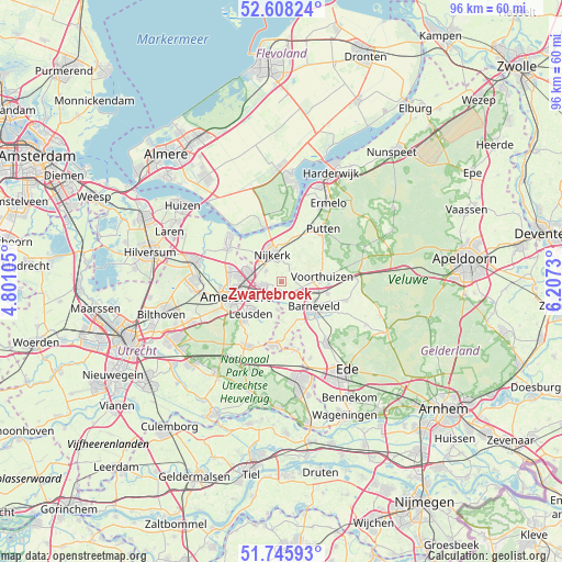
Zwartebroek GPS coordinates[2]
52° 10' 45.012" North, 5° 30' 15.012" East
| Map corner | latitude | longitude |
|---|---|---|
| Upper-left | 52.60824°, | 4.80105° |
| Center: | 52.17917°, | 5.50417° |
| Lower-right: | 51.74593°, | 6.2073° |
| Map W x H: | 95.9×95.9 km | = 59.6×59.6mi |
| max Lat: | 53.48025° ⇑41.5% North |
| Zwartebroek: | 52.17917° |
| min Lat: | ⇓58.5% South 50.76917° |
| min Long | Zwartebroek | max Long |
| 3.38611° | 5.50417° | 7.16528° |
| W 43.7%⇐ | ⇒56.3% E |
Elevation
Elevation of Zwartebroek is 6 m = 20 ft, and this is 9 m = 30 ft below average elevation for this country.
| Max E: |
203 m = 666 ft | 50.6% |
| Avg. | 15 m = 49 ft | |
| Zwartebroek | 6 m = 20 ft | |
Min E: |
-6 m = -20 ft | 49.4% |
See also: Netherlands elevation on elevation.city.
Geographical zone
Zwartebroek is located in North temperate zone (between Tropic of Cancer and the Arctic Circle). Distance of this North polar circle is 1599.4 km =993.8 mi to North.| Distance of | km | miles | from Zwartebroek |
|---|---|---|---|
| North Pole | 4205.3 | 2613.1 | to North |
| Arctic Circle | 1599.4 | 993.8 | to North |
| Tropic Cancer | 3195.9 | 1985.8 | to South |
| Equator | 5801.8 | 3605.1 | to South |


Nearby cities:
15 places around Zwartebroek: (largest is in red/bold)
• Amersfoort
8.4 km =5.2 mi,  251°
251°
• Appel
2.6 km =1.6 mi,  69°
69°
• Barneveld
7 km =4.3 mi,  128°
128°
• Corlaer
4.9 km =3 mi,  327°
327°
• Doornsteeg
6.6 km =4.1 mi, 328°
• Hoogland
8.9 km =5.5 mi,  272°
272°
• Langenoord
8.5 km =5.3 mi,  276°
276°
• Leusden
7.2 km =4.5 mi,  223°
223°
• Nederwoud
9.8 km =6.1 mi,  152°
152°
• Nijkerk
4.7 km =2.9 mi,  344°
344°
• Nijkerkerveen
3.1 km =1.9 mi,  304°
304°
• Randenbroek
7.8 km =4.8 mi,  244°
244°
• Scherpenzeel
11.1 km =6.9 mi,  185°
185°
• Terschuur
1.8 km =1.1 mi, 151°
• Voorthuizen
7 km =4.3 mi,  83°
83°
Sources, notices
• [Note1] Compared only with cities in Netherlands existing in our database
• [Src1] Map data: © OpenStreetMap contributors (CC-BY-SA)
• [Src2] Other city data from geonames.org with taken over terms of usage.
• [Src3] Geographical zone / Annual Mean Temperature by Robert A. Rohde @ Wikipedia
