Simpelveld geodata
Simpelveld (Limburg) is a populated place; located in Netherlands in Europe/Amsterdam (GMT+2) time zone. With population of 2,405 people, there are 861 cities with bigger population in this country. Compared to other cities in Netherlands, 98.7% of cities are located further ↑North; 71.3% of cities are located further ←West and 98.6% of cities have lower elevation than Simpelveld. Note1


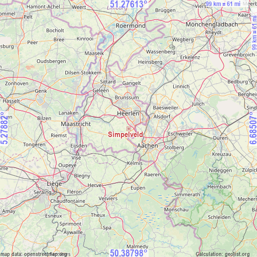
Simpelveld GPS coordinates[2]
50° 50' 3.012" North, 5° 58' 54.984" East
| Map corner | latitude | longitude |
|---|---|---|
| Upper-left | 51.27613°, | 5.27882° |
| Center: | 50.83417°, | 5.98194° |
| Lower-right: | 50.38798°, | 6.68507° |
| Map W x H: | 98.8×98.8 km | = 61.4×61.4mi |
| max Lat: | 53.48025° ⇑98.7% North |
| Simpelveld: | 50.83417° |
| min Lat: | ⇓1.3% South 50.76917° |
| min Long | Simpelveld | max Long |
| 3.38611° | 5.98194° | 7.16528° |
| W 71.3%⇐ | ⇒28.7% E |
Elevation
Elevation of Simpelveld is 138 m = 453 ft, and this is 123 m = 404 ft above average elevation for this country.
| Max E: |
203 m = 666 ft | 1.4% |
| Simpelveld | 138 m 453 ft | |
| Avg. | 15 m = 49 ft | |
Min E: |
-6 m = -20 ft | 98.6% |
See also: Netherlands elevation on elevation.city.
Geographical zone
Simpelveld is located in North temperate zone (between Tropic of Cancer and the Arctic Circle). Distance of this North polar circle is 1748.9 km =1086.7 mi to North.| Distance of | km | miles | from Simpelveld |
|---|---|---|---|
| North Pole | 4354.8 | 2705.9 | to North |
| Arctic Circle | 1748.9 | 1086.7 | to North |
| Tropic Cancer | 3046.3 | 1892.9 | to South |
| Equator | 5652.2 | 3512.1 | to South |


Nearby cities:
15 places around Simpelveld: (largest is in red/bold)
• Bleijerheide
6.5 km =4 mi,  68°
68°
• Bocholtz
2.4 km =1.5 mi,  136°
136°
• Bocholtzerheide
2.1 km =1.3 mi,  163°
163°
• Gracht
3.8 km =2.4 mi,  58°
58°
• Heerlen
5.5 km =3.4 mi,  359°
359°
• Kaalheide
5.1 km =3.2 mi,  48°
48°
• Kunrade
6 km =3.7 mi,  323°
323°
• Lemiers
5.4 km =3.4 mi,  171°
171°
• Mechelen
5.8 km =3.6 mi,  222°
222°
• Nijswiller
3.3 km =2.1 mi,  212°
212°
• Spekholzerheide
3.8 km =2.4 mi, 51°
• Terwinselen
4.7 km =2.9 mi,  39°
39°
• Ubachsberg
3.2 km =2 mi,  312°
312°
• Vijlen
5.2 km =3.2 mi,  192°
192°
• Wijlre
6 km =3.7 mi,  269°
269°
Sources, notices
• [Note1] Compared only with cities in Netherlands existing in our database
• [Src1] Map data: © OpenStreetMap contributors (CC-BY-SA)
• [Src2] Other city data from geonames.org with taken over terms of usage.
• [Src3] Geographical zone / Annual Mean Temperature by Robert A. Rohde @ Wikipedia
