Lelystad geodata
Lelystad (Flevoland) is a seat of a first-order administrative division; located in Netherlands in Europe/Amsterdam (GMT+2) time zone. With population of 70,741 people, there are 43 cities with bigger population in this country. Compared to other cities in Netherlands, 71.6% of cities are located further ↓South; 57.8% of cities are located further →East and 96.1% of cities have higher elevation than Lelystad. Note1


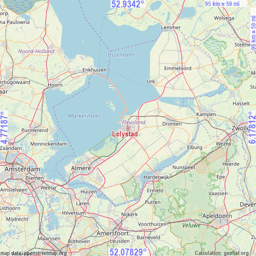
Lelystad GPS coordinates[2]
52° 30' 29.988" North, 5° 28' 30" East
| Map corner | latitude | longitude |
|---|---|---|
| Upper-left | 52.9342°, | 4.77187° |
| Center: | 52.50833°, | 5.475° |
| Lower-right: | 52.07829°, | 6.17812° |
| Map W x H: | 95.2×95.2 km | = 59.2×59.2mi |
| max Lat: | 53.48025° ⇑28.4% North |
| Lelystad: | 52.50833° |
| min Lat: | ⇓71.6% South 50.76917° |
| min Long | Lelystad | max Long |
| 3.38611° | 5.475° | 7.16528° |
| W 42.2%⇐ | ⇒57.8% E |
Elevation
Elevation of Lelystad is -1 m = -3 ft, and this is 16 m = 52 ft below average elevation for this country.
| Max E: |
203 m = 666 ft | 96.1% |
| Avg. | 15 m = 49 ft | |
| Lelystad | -1 m = -3 ft | |
Min E: |
-6 m = -20 ft | 3.9% |
See also: Lelystad elevation on elevation.city.
Geographical zone
Lelystad is located in North temperate zone (between Tropic of Cancer and the Arctic Circle). Distance of this North polar circle is 1562.8 km =971.1 mi to North.| Distance of | km | miles | from Lelystad |
|---|---|---|---|
| North Pole | 4168.7 | 2590.3 | to North |
| Arctic Circle | 1562.8 | 971.1 | to North |
| Tropic Cancer | 3232.5 | 2008.6 | to South |
| Equator | 5838.4 | 3627.8 | to South |


Nearby cities:
15 places around Lelystad: (largest is in red/bold)
• Almere Stad
23.4 km =14.5 mi,  229°
229°
• Biddinghuizen
15.9 km =9.9 mi,  111°
111°
• Broekerhaven
25 km =15.5 mi,  323°
323°
• Doornspijk
25.3 km =15.7 mi, 113°
• Dronten
16.6 km =10.3 mi,  83°
83°
• Elburg
25.8 km =16 mi, 105°
• Enkhuizen
25 km =15.5 mi,  330°
330°
• Ermelo
25.4 km =15.8 mi,  156°
156°
• Harderwijk
21 km =13 mi,  151°
151°
• Hulshorst
23.7 km =14.7 mi,  132°
132°
• Ketelhaven
21 km =13 mi,  68°
68°
• Nunspeet
25.5 km =15.8 mi,  124°
124°
• Urk
19.2 km =11.9 mi,  26°
26°
• Wijdenes
25.7 km =16 mi,  303°
303°
• Zeewolde
20.3 km =12.6 mi,  167°
167°
Sources, notices
• [Note1] Compared only with cities in Netherlands existing in our database
• [Src1] Map data: © OpenStreetMap contributors (CC-BY-SA)
• [Src2] Other city data from geonames.org with taken over terms of usage.
• [Src3] Geographical zone / Annual Mean Temperature by Robert A. Rohde @ Wikipedia
