Kloosterburen geodata
Kloosterburen (Groningen) is a populated place; located in Netherlands in Europe/Amsterdam (GMT+2) time zone. With population of 575 people, there are 1747 cities with bigger population in this country. Compared to other cities in Netherlands, 99.5% of cities are located further ↓South; 87.1% of cities are located further ←West and 74.9% of cities have higher elevation than Kloosterburen. Note1


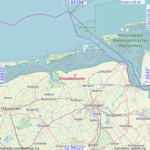
Kloosterburen GPS coordinates[2]
53° 23' 12.012" North, 6° 23' 30.012" East
| Map corner | latitude | longitude |
|---|---|---|
| Upper-left | 53.80396°, | 5.68855° |
| Center: | 53.38667°, | 6.39167° |
| Lower-right: | 52.96525°, | 7.0948° |
| Map W x H: | 93.3×93.3 km | = 58×58mi |
| max Lat: | 53.48025° ⇑0.5% North |
| Kloosterburen: | 53.38667° |
| min Lat: | ⇓99.5% South 50.76917° |
| min Long | Kloosterburen | max Long |
| 3.38611° | 6.39167° | 7.16528° |
| W 87.1%⇐ | ⇒12.9% E |
Elevation
Elevation of Kloosterburen is 2 m = 7 ft, and this is 13 m = 43 ft below average elevation for this country.
| Max E: |
203 m = 666 ft | 74.9% |
| Avg. | 15 m = 49 ft | |
| Kloosterburen | 2 m = 7 ft | |
Min E: |
-6 m = -20 ft | 25.1% |
See also: Netherlands elevation on elevation.city.
Geographical zone
Kloosterburen is located in North temperate zone (between Tropic of Cancer and the Arctic Circle). Distance of this North polar circle is 1465.1 km =910.4 mi to North.| Distance of | km | miles | from Kloosterburen |
|---|---|---|---|
| North Pole | 4071 | 2529.6 | to North |
| Arctic Circle | 1465.1 | 910.4 | to North |
| Tropic Cancer | 3330.1 | 2069.2 | to South |
| Equator | 5936 | 3688.5 | to South |


Nearby cities:
15 places around Kloosterburen: (largest is in red/bold)
• Baflo
8.5 km =5.3 mi,  108°
108°
• Eenrum
5.2 km =3.2 mi,  121°
121°
• Ezinge
9.1 km =5.7 mi,  158°
158°
• Kommerzijl
12 km =7.5 mi,  201°
201°
• Leens
3.1 km =1.9 mi, 195°
• Noordhorn
13.9 km =8.6 mi,  178°
178°
• Obergum
10.2 km =6.3 mi,  125°
125°
• Oldehove
9.3 km =5.8 mi, 178°
• Onderdendam
14.4 km =8.9 mi, 113°
• Sauwerd
14.1 km =8.8 mi,  137°
137°
• Ulrum
4.9 km =3 mi,  231°
231°
• Usquert
14.7 km =9.1 mi,  83°
83°
• Warffum
11.1 km =6.9 mi,  86°
86°
• Winsum
10.6 km =6.6 mi, 126°
• Zoutkamp
7.8 km =4.8 mi, 227°
Sources, notices
• [Note1] Compared only with cities in Netherlands existing in our database
• [Src1] Map data: © OpenStreetMap contributors (CC-BY-SA)
• [Src2] Other city data from geonames.org with taken over terms of usage.
• [Src3] Geographical zone / Annual Mean Temperature by Robert A. Rohde @ Wikipedia
