Zoutkamp geodata
Zoutkamp (Groningen) is a populated place; located in Netherlands in Europe/Amsterdam (GMT+2) time zone. With population of 1,215 people, there are 1282 cities with bigger population in this country. Compared to other cities in Netherlands, 98.5% of cities are located further ↓South; 85.6% of cities are located further ←West and 91.3% of cities have higher elevation than Zoutkamp. Note1


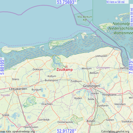
Zoutkamp GPS coordinates[2]
53° 20' 21.012" North, 6° 18' 15.012" East
| Map corner | latitude | longitude |
|---|---|---|
| Upper-left | 53.75693°, | 5.60105° |
| Center: | 53.33917°, | 6.30417° |
| Lower-right: | 52.91728°, | 7.0073° |
| Map W x H: | 93.4×93.4 km | = 58×58mi |
| max Lat: | 53.48025° ⇑1.5% North |
| Zoutkamp: | 53.33917° |
| min Lat: | ⇓98.5% South 50.76917° |
| min Long | Zoutkamp | max Long |
| 3.38611° | 6.30417° | 7.16528° |
| W 85.6%⇐ | ⇒14.4% E |
Elevation
Elevation of Zoutkamp is 0 m = 0 ft, and this is 15 m = 49 ft below average elevation for this country.
| Max E: |
203 m = 666 ft | 91.3% |
| Avg. | 15 m = 49 ft | |
| Zoutkamp | 0 m = 0 ft | |
Min E: |
-6 m = -20 ft | 8.7% |
See also: Netherlands elevation on elevation.city.
Geographical zone
Zoutkamp is located in North temperate zone (between Tropic of Cancer and the Arctic Circle). Distance of this North polar circle is 1470.4 km =913.7 mi to North.| Distance of | km | miles | from Zoutkamp |
|---|---|---|---|
| North Pole | 4076.3 | 2532.9 | to North |
| Arctic Circle | 1470.4 | 913.7 | to North |
| Tropic Cancer | 3324.8 | 2065.9 | to South |
| Equator | 5930.8 | 3685.2 | to South |


Nearby cities:
15 places around Zoutkamp: (largest is in red/bold)
• Anjum
12.4 km =7.7 mi,  288°
288°
• Burum
8.8 km =5.5 mi,  214°
214°
• Eenrum
10.6 km =6.6 mi,  75°
75°
• Ezinge
9.7 km =6 mi,  109°
109°
• Grijpskerk
8.5 km =5.3 mi,  178°
178°
• Kloosterburen
7.8 km =4.8 mi,  47°
47°
• Kollum
12.2 km =7.6 mi,  235°
235°
• Kommerzijl
6 km =3.7 mi,  166°
166°
• Leens
5.5 km =3.4 mi,  65°
65°
• Lutjegast
12.1 km =7.5 mi,  194°
194°
• Niekerk
13.1 km =8.1 mi, 165°
• Noordhorn
10.6 km =6.6 mi,  144°
144°
• Oldehove
7.3 km =4.5 mi,  123°
123°
• Ulrum
2.9 km =1.8 mi,  41°
41°
• Zuidhorn
12.2 km =7.6 mi,  147°
147°
Sources, notices
• [Note1] Compared only with cities in Netherlands existing in our database
• [Src1] Map data: © OpenStreetMap contributors (CC-BY-SA)
• [Src2] Other city data from geonames.org with taken over terms of usage.
• [Src3] Geographical zone / Annual Mean Temperature by Robert A. Rohde @ Wikipedia
