Halfweg geodata
Halfweg (North Holland) is a populated place; located in Netherlands in Europe/Amsterdam (GMT+2) time zone. With population of 2,350 people, there are 882 cities with bigger population in this country. Compared to other cities in Netherlands, 68.8% of cities are located further ↓South; 81.8% of cities are located further →East and 74.9% of cities have higher elevation than Halfweg. Note1


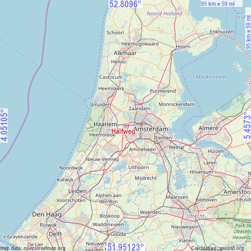
Halfweg GPS coordinates[2]
52° 22' 57" North, 4° 45' 15.012" East
| Map corner | latitude | longitude |
|---|---|---|
| Upper-left | 52.8096°, | 4.05105° |
| Center: | 52.3825°, | 4.75417° |
| Lower-right: | 51.95123°, | 5.4573° |
| Map W x H: | 95.4×95.4 km | = 59.3×59.3mi |
| max Lat: | 53.48025° ⇑31.2% North |
| Halfweg: | 52.3825° |
| min Lat: | ⇓68.8% South 50.76917° |
| min Long | Halfweg | max Long |
| 3.38611° | 4.75417° | 7.16528° |
| W 18.2%⇐ | ⇒81.8% E |
Elevation
Elevation of Halfweg is 2 m = 7 ft, and this is 13 m = 43 ft below average elevation for this country.
| Max E: |
203 m = 666 ft | 74.9% |
| Avg. | 15 m = 49 ft | |
| Halfweg | 2 m = 7 ft | |
Min E: |
-6 m = -20 ft | 25.1% |
See also: Netherlands elevation on elevation.city.
Geographical zone
Halfweg is located in North temperate zone (between Tropic of Cancer and the Arctic Circle). Distance of this North polar circle is 1576.8 km =979.8 mi to North.| Distance of | km | miles | from Halfweg |
|---|---|---|---|
| North Pole | 4182.7 | 2599 | to North |
| Arctic Circle | 1576.8 | 979.8 | to North |
| Tropic Cancer | 3218.5 | 1999.9 | to South |
| Equator | 5824.4 | 3619.1 | to South |


Nearby cities:
15 places around Halfweg: (largest is in red/bold)
• Amsterdam
9.2 km =5.7 mi,  95°
95°
• Bloemendaal
9.2 km =5.7 mi,  283°
283°
• Cruquius
9.6 km =6 mi,  237°
237°
• Haarlem
8 km =5 mi,  268°
268°
• Heemstede
9.6 km =6 mi,  247°
247°
• Hofgeest
9.4 km =5.8 mi,  316°
316°
• Hoofddorp
9.9 km =6.2 mi,  206°
206°
• Kadoelen
11 km =6.8 mi,  69°
69°
• Lijnden
3.3 km =2.1 mi,  176°
176°
• Overveen
9.6 km =6 mi, 276°
• Velsen-Zuid
11.1 km =6.9 mi, 320°
• Vijfhuizen
6.3 km =3.9 mi, 235°
• Zaandam
7.9 km =4.9 mi,  38°
38°
• Zaandijk
10.9 km =6.8 mi,  19°
19°
• Zaanstad
8.8 km =5.5 mi,  27°
27°
Sources, notices
• [Note1] Compared only with cities in Netherlands existing in our database
• [Src1] Map data: © OpenStreetMap contributors (CC-BY-SA)
• [Src2] Other city data from geonames.org with taken over terms of usage.
• [Src3] Geographical zone / Annual Mean Temperature by Robert A. Rohde @ Wikipedia
