Haarle geodata
Haarle (Overijssel) is a populated place; located in Netherlands in Europe/Amsterdam (GMT+2) time zone. With population of 1,045 people, there are 1367 cities with bigger population in this country. Compared to other cities in Netherlands, 68.3% of cities are located further ↓South; 87% of cities are located further ←West and 69% of cities have lower elevation than Haarle. Note1


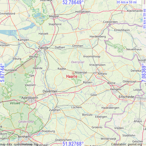
Haarle GPS coordinates[2]
52° 21' 33.012" North, 6° 22' 50.016" East
| Map corner | latitude | longitude |
|---|---|---|
| Upper-left | 52.78649°, | 5.67744° |
| Center: | 52.35917°, | 6.38056° |
| Lower-right: | 51.92768°, | 7.08369° |
| Map W x H: | 95.5×95.5 km | = 59.3×59.3mi |
| max Lat: | 53.48025° ⇑31.7% North |
| Haarle: | 52.35917° |
| min Lat: | ⇓68.3% South 50.76917° |
| min Long | Haarle | max Long |
| 3.38611° | 6.38056° | 7.16528° |
| W 87%⇐ | ⇒13% E |
Elevation
Elevation of Haarle is 14 m = 46 ft, and this is 1 m = 3 ft below average elevation for this country.
| Max E: |
203 m = 666 ft | 31% |
| Avg. | 15 m = 49 ft | |
| Haarle | 14 m = 46 ft | |
Min E: |
-6 m = -20 ft | 69% |
See also: Netherlands elevation on elevation.city.
Geographical zone
Haarle is located in North temperate zone (between Tropic of Cancer and the Arctic Circle). Distance of this North polar circle is 1579.4 km =981.4 mi to North.| Distance of | km | miles | from Haarle |
|---|---|---|---|
| North Pole | 4185.3 | 2600.6 | to North |
| Arctic Circle | 1579.4 | 981.4 | to North |
| Tropic Cancer | 3215.9 | 1998.3 | to South |
| Equator | 5821.8 | 3617.5 | to South |


Nearby cities:
15 places around Haarle: (largest is in red/bold)
• Daarle
13.5 km =8.4 mi,  51°
51°
• Den Ham
14.2 km =8.8 mi,  33°
33°
• Elsen
14.6 km =9.1 mi,  132°
132°
• Elshof
12.8 km =8 mi,  287°
287°
• Heino
13.2 km =8.2 mi,  310°
310°
• Hellendoorn
5.8 km =3.6 mi,  56°
56°
• Het Oostrik
16.5 km =10.3 mi,  222°
222°
• Hulsen
6.7 km =4.2 mi,  70°
70°
• Loo
12.2 km =7.6 mi,  193°
193°
• Magele
15.5 km =9.6 mi,  37°
37°
• Markelo
16 km =9.9 mi,  149°
149°
• Marle
9.9 km =6.2 mi, 43°
• Raalte
7.8 km =4.8 mi, 292°
• Schalkhaar
16.2 km =10.1 mi,  231°
231°
• Wierden
14.4 km =8.9 mi,  90°
90°
Sources, notices
• [Note1] Compared only with cities in Netherlands existing in our database
• [Src1] Map data: © OpenStreetMap contributors (CC-BY-SA)
• [Src2] Other city data from geonames.org with taken over terms of usage.
• [Src3] Geographical zone / Annual Mean Temperature by Robert A. Rohde @ Wikipedia
