Hummelo geodata
Hummelo (Gelderland) is a populated place; located in Netherlands in Europe/Amsterdam (GMT+2) time zone. With population of 1,010 people, there are 1391 cities with bigger population in this country. Compared to other cities in Netherlands, 50.7% of cities are located further ↑North; 84.2% of cities are located further ←West and 67% of cities have lower elevation than Hummelo. Note1


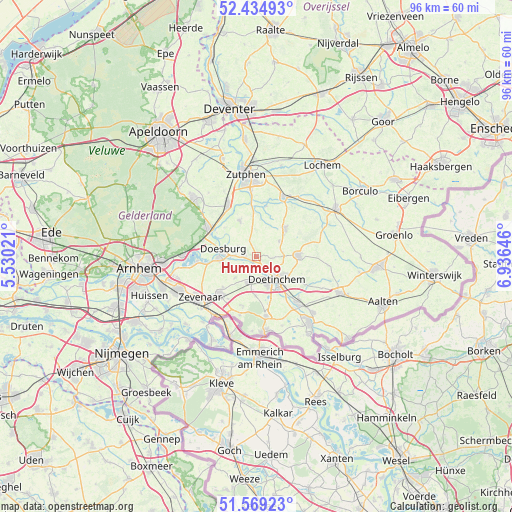
Hummelo GPS coordinates[2]
52° 0' 15.012" North, 6° 13' 59.988" East
| Map corner | latitude | longitude |
|---|---|---|
| Upper-left | 52.43493°, | 5.53021° |
| Center: | 52.00417°, | 6.23333° |
| Lower-right: | 51.56923°, | 6.93646° |
| Map W x H: | 96.3×96.3 km | = 59.8×59.8mi |
| max Lat: | 53.48025° ⇑50.7% North |
| Hummelo: | 52.00417° |
| min Lat: | ⇓49.3% South 50.76917° |
| min Long | Hummelo | max Long |
| 3.38611° | 6.23333° | 7.16528° |
| W 84.2%⇐ | ⇒15.8% E |
Elevation
Elevation of Hummelo is 13 m = 43 ft, and this is 2 m = 7 ft below average elevation for this country.
| Max E: |
203 m = 666 ft | 33% |
| Avg. | 15 m = 49 ft | |
| Hummelo | 13 m = 43 ft | |
Min E: |
-6 m = -20 ft | 67% |
See also: Netherlands elevation on elevation.city.
Geographical zone
Hummelo is located in North temperate zone (between Tropic of Cancer and the Arctic Circle). Distance of this North polar circle is 1618.9 km =1005.9 mi to North.| Distance of | km | miles | from Hummelo |
|---|---|---|---|
| North Pole | 4224.7 | 2625.1 | to North |
| Arctic Circle | 1618.9 | 1005.9 | to North |
| Tropic Cancer | 3176.4 | 1973.7 | to South |
| Equator | 5782.3 | 3593 | to South |


Nearby cities:
15 places around Hummelo: (largest is in red/bold)
• Angerlo
6.8 km =4.2 mi,  262°
262°
• Baak
8.2 km =5.1 mi,  357°
357°
• Braamt
9.3 km =5.8 mi,  166°
166°
• Doesburg
6.5 km =4 mi,  278°
278°
• Doetinchem
5.8 km =3.6 mi,  138°
138°
• Drempt
4 km =2.5 mi, 275°
• Ellecom
10.5 km =6.5 mi,  287°
287°
• Hengelo
7.4 km =4.6 mi,  45°
45°
• Keijenborg
5 km =3.1 mi,  56°
56°
• Kilder
7.4 km =4.6 mi,  180°
180°
• Loil
8.4 km =5.2 mi,  227°
227°
• Nieuw-Dijk
9.5 km =5.9 mi,  214°
214°
• Spankeren
10.2 km =6.3 mi,  306°
306°
• Steenderen
7.4 km =4.6 mi,  334°
334°
• Zelhem
7.9 km =4.9 mi,  87°
87°
Sources, notices
• [Note1] Compared only with cities in Netherlands existing in our database
• [Src1] Map data: © OpenStreetMap contributors (CC-BY-SA)
• [Src2] Other city data from geonames.org with taken over terms of usage.
• [Src3] Geographical zone / Annual Mean Temperature by Robert A. Rohde @ Wikipedia
