Broek in Waterland geodata
Broek in Waterland (North Holland) is a populated place; located in Netherlands in Europe/Amsterdam (GMT+2) time zone. With population of 2,655 people, there are 811 cities with bigger population in this country. Compared to other cities in Netherlands, 69.7% of cities are located further ↓South; 73.7% of cities are located further →East and 91.3% of cities have higher elevation than Broek in Waterland. Note1


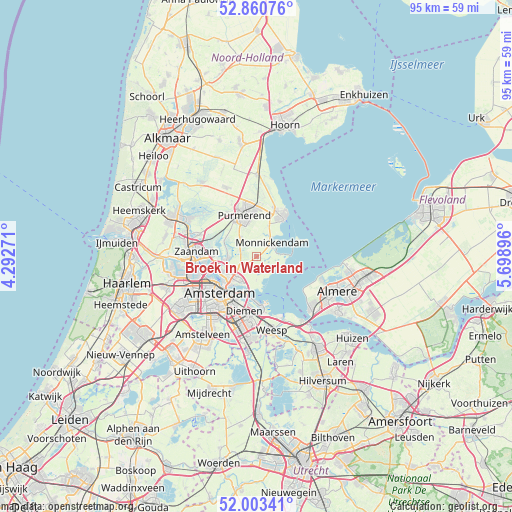
Broek in Waterland GPS coordinates[2]
52° 26' 3.012" North, 4° 59' 44.988" East
| Map corner | latitude | longitude |
|---|---|---|
| Upper-left | 52.86076°, | 4.29271° |
| Center: | 52.43417°, | 4.99583° |
| Lower-right: | 52.00341°, | 5.69896° |
| Map W x H: | 95.3×95.3 km | = 59.2×59.2mi |
| max Lat: | 53.48025° ⇑30.3% North |
| Broek in Waterland: | 52.43417° |
| min Lat: | ⇓69.7% South 50.76917° |
| min Long | Broek in Waterl | max Long |
| 3.38611° | 4.99583° | 7.16528° |
| W 26.3%⇐ | ⇒73.7% E |
Elevation
Elevation of Broek in Waterland is 0 m = 0 ft, and this is 15 m = 49 ft below average elevation for this country.
| Max E: |
203 m = 666 ft | 91.3% |
| Avg. | 15 m = 49 ft | |
| Broek in Waterland | 0 m = 0 ft | |
Min E: |
-6 m = -20 ft | 8.7% |
See also: Netherlands elevation on elevation.city.
Geographical zone
Broek in Waterland is located in North temperate zone (between Tropic of Cancer and the Arctic Circle). Distance of this North polar circle is 1571 km =976.2 mi to North.| Distance of | km | miles | from Broek in Waterland |
|---|---|---|---|
| North Pole | 4176.9 | 2595.4 | to North |
| Arctic Circle | 1571 | 976.2 | to North |
| Tropic Cancer | 3224.2 | 2003.4 | to South |
| Equator | 5830.1 | 3622.7 | to South |


Nearby cities:
15 places around Broek in Waterland: (largest is in red/bold)
• Amsterdam
9.8 km =6.1 mi,  227°
227°
• Den Ilp
6.4 km =4 mi,  290°
290°
• Diemen
10.8 km =6.7 mi,  192°
192°
• Edam
9.4 km =5.8 mi,  22°
22°
• Halfweg
11 km =6.8 mi,  335°
335°
• Ilpendam
4.5 km =2.8 mi,  316°
316°
• Kadoelen
6.4 km =4 mi,  253°
253°
• Kwadijk
10.5 km =6.5 mi,  354°
354°
• Landsmeer
5.5 km =3.4 mi,  266°
266°
• Marken
7.7 km =4.8 mi,  69°
69°
• Middelie
11 km =6.8 mi,  7°
7°
• Monnickendam
3.9 km =2.4 mi,  46°
46°
• Purmerend
8.2 km =5.1 mi, 342°
• Volendam
8.5 km =5.3 mi,  36°
36°
• Zaandam
11.5 km =7.1 mi, 272°
Sources, notices
• [Note1] Compared only with cities in Netherlands existing in our database
• [Src1] Map data: © OpenStreetMap contributors (CC-BY-SA)
• [Src2] Other city data from geonames.org with taken over terms of usage.
• [Src3] Geographical zone / Annual Mean Temperature by Robert A. Rohde @ Wikipedia
