Amsterdam geodata
Amsterdam (North Holland) is a capital of a political entity; located in Netherlands in Europe/Amsterdam (GMT+2) time zone. With population of 741,636 people, there are 0 cities with bigger population in this country. Compared to other cities in Netherlands, 68.5% of cities are located further ↓South; 76.7% of cities are located further →East and 67% of cities have lower elevation than Amsterdam. Note1


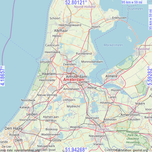
Amsterdam GPS coordinates[2]
52° 22' 26.508" North, 4° 53' 22.884" East
| Map corner | latitude | longitude |
|---|---|---|
| Upper-left | 52.80121°, | 4.18657° |
| Center: | 52.37403°, | 4.88969° |
| Lower-right: | 51.94268°, | 5.59282° |
| Map W x H: | 95.5×95.5 km | = 59.3×59.3mi |
| max Lat: | 53.48025° ⇑31.5% North |
| Amsterdam: | 52.37403° |
| min Lat: | ⇓68.5% South 50.76917° |
| min Long | Amsterdam | max Long |
| 3.38611° | 4.88969° | 7.16528° |
| W 23.3%⇐ | ⇒76.7% E |
Elevation
Elevation of Amsterdam is 13 m = 43 ft, and this is 2 m = 7 ft below average elevation for this country.
| Max E: |
203 m = 666 ft | 33% |
| Avg. | 15 m = 49 ft | |
| Amsterdam | 13 m = 43 ft | |
Min E: |
-6 m = -20 ft | 67% |
See also: Amsterdam elevation on elevation.city.
Geographical zone
Amsterdam is located in North temperate zone (between Tropic of Cancer and the Arctic Circle). Distance of this North polar circle is 1577.7 km =980.3 mi to North.| Distance of | km | miles | from Amsterdam |
|---|---|---|---|
| North Pole | 4183.6 | 2599.6 | to North |
| Arctic Circle | 1577.7 | 980.3 | to North |
| Tropic Cancer | 3217.5 | 1999.3 | to South |
| Equator | 5823.4 | 3618.5 | to South |


Nearby cities:
15 places around Amsterdam: (largest is in red/bold)
• Amstelveen
8.3 km =5.2 mi,  192°
192°
• Amsterdam-Zuidoost
9.3 km =5.8 mi,  142°
142°
• Broek in Waterland
9.8 km =6.1 mi,  47°
47°
• Den Ilp
9 km =5.6 mi,  7°
7°
• Diemen
6.3 km =3.9 mi,  127°
127°
• Driemond
11.5 km =7.1 mi, 131°
• Duivendrecht
6 km =3.7 mi,  145°
145°
• Halfweg
9.2 km =5.7 mi,  275°
275°
• Ilpendam
10.7 km =6.6 mi,  22°
22°
• Kadoelen
5 km =3.1 mi, 12°
• Landsmeer
6.5 km =4 mi, 15°
• Lijnden
9.3 km =5.8 mi,  255°
255°
• Ouderkerk aan de Amstel
8.9 km =5.5 mi,  172°
172°
• Zaandam
8.4 km =5.2 mi,  329°
329°
• Zaanstad
10.2 km =6.3 mi, 329°
Sources, notices
• [Note1] Compared only with cities in Netherlands existing in our database
• [Src1] Map data: © OpenStreetMap contributors (CC-BY-SA)
• [Src2] Other city data from geonames.org with taken over terms of usage.
• [Src3] Geographical zone / Annual Mean Temperature by Robert A. Rohde @ Wikipedia
