Zaandam geodata
Zaandam (North Holland) is a populated place; located in Netherlands in Europe/Amsterdam (GMT+2) time zone. With population of 71,708 people, there are 42 cities with bigger population in this country. Compared to other cities in Netherlands, 69.9% of cities are located further ↓South; 78.5% of cities are located further →East and 96.1% of cities have higher elevation than Zaandam. Note1


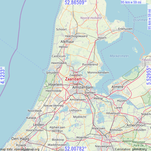
Zaandam GPS coordinates[2]
52° 26' 18.744" North, 4° 49' 35.148" East
| Map corner | latitude | longitude |
|---|---|---|
| Upper-left | 52.86509°, | 4.1233° |
| Center: | 52.43854°, | 4.82643° |
| Lower-right: | 52.00782°, | 5.52955° |
| Map W x H: | 95.3×95.3 km | = 59.2×59.2mi |
| max Lat: | 53.48025° ⇑30.1% North |
| Zaandam: | 52.43854° |
| min Lat: | ⇓69.9% South 50.76917° |
| min Long | Zaandam | max Long |
| 3.38611° | 4.82643° | 7.16528° |
| W 21.5%⇐ | ⇒78.5% E |
Elevation
Elevation of Zaandam is -1 m = -3 ft, and this is 16 m = 52 ft below average elevation for this country.
| Max E: |
203 m = 666 ft | 96.1% |
| Avg. | 15 m = 49 ft | |
| Zaandam | -1 m = -3 ft | |
Min E: |
-6 m = -20 ft | 3.9% |
See also: Zaandam elevation on elevation.city.
Geographical zone
Zaandam is located in North temperate zone (between Tropic of Cancer and the Arctic Circle). Distance of this North polar circle is 1570.6 km =975.9 mi to North.| Distance of | km | miles | from Zaandam |
|---|---|---|---|
| North Pole | 4176.4 | 2595.1 | to North |
| Arctic Circle | 1570.6 | 975.9 | to North |
| Tropic Cancer | 3224.7 | 2003.7 | to South |
| Equator | 5830.6 | 3623 | to South |


Nearby cities:
15 places around Zaandam: (largest is in red/bold)
• Amsterdam
8.4 km =5.2 mi,  149°
149°
• Broek in Waterland
11.5 km =7.1 mi,  92°
92°
• Den Ilp
5.7 km =3.5 mi,  72°
72°
• Halfweg
7.9 km =4.9 mi,  218°
218°
• Halfweg
11.7 km =7.3 mi,  35°
35°
• Hofgeest
11.4 km =7.1 mi,  272°
272°
• Ilpendam
8.8 km =5.5 mi, 71°
• Kadoelen
5.9 km =3.7 mi,  113°
113°
• Landsmeer
6.1 km =3.8 mi,  98°
98°
• Langeheit
7.5 km =4.7 mi,  322°
322°
• Lijnden
10.7 km =6.6 mi,  206°
206°
• Oostknollendam
9.1 km =5.7 mi,  344°
344°
• Purmerend
11.7 km =7.3 mi,  50°
50°
• Zaandijk
4.3 km =2.7 mi, 341°
• Zaanstad
1.8 km =1.1 mi,  331°
331°
Sources, notices
• [Note1] Compared only with cities in Netherlands existing in our database
• [Src1] Map data: © OpenStreetMap contributors (CC-BY-SA)
• [Src2] Other city data from geonames.org with taken over terms of usage.
• [Src3] Geographical zone / Annual Mean Temperature by Robert A. Rohde @ Wikipedia
