Landsmeer geodata
Landsmeer (North Holland) is a populated place; located in Netherlands in Europe/Amsterdam (GMT+2) time zone. With population of 1,800 people, there are 1018 cities with bigger population in this country. Compared to other cities in Netherlands, 69.7% of cities are located further ↓South; 75.8% of cities are located further →East and 74.9% of cities have higher elevation than Landsmeer. Note1


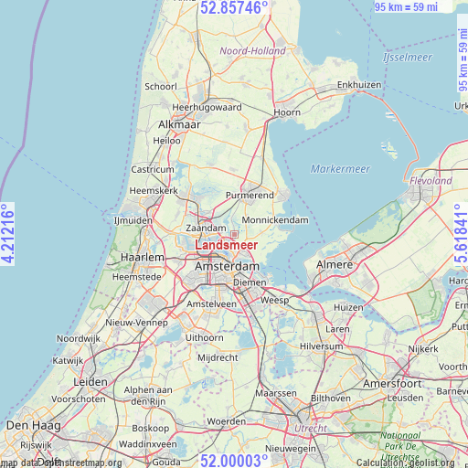
Landsmeer GPS coordinates[2]
52° 25' 50.988" North, 4° 54' 55.008" East
| Map corner | latitude | longitude |
|---|---|---|
| Upper-left | 52.85746°, | 4.21216° |
| Center: | 52.43083°, | 4.91528° |
| Lower-right: | 52.00003°, | 5.61841° |
| Map W x H: | 95.3×95.3 km | = 59.2×59.2mi |
| max Lat: | 53.48025° ⇑30.3% North |
| Landsmeer: | 52.43083° |
| min Lat: | ⇓69.7% South 50.76917° |
| min Long | Landsmeer | max Long |
| 3.38611° | 4.91528° | 7.16528° |
| W 24.2%⇐ | ⇒75.8% E |
Elevation
Elevation of Landsmeer is 2 m = 7 ft, and this is 13 m = 43 ft below average elevation for this country.
| Max E: |
203 m = 666 ft | 74.9% |
| Avg. | 15 m = 49 ft | |
| Landsmeer | 2 m = 7 ft | |
Min E: |
-6 m = -20 ft | 25.1% |
See also: Netherlands elevation on elevation.city.
Geographical zone
Landsmeer is located in North temperate zone (between Tropic of Cancer and the Arctic Circle). Distance of this North polar circle is 1571.4 km =976.4 mi to North.| Distance of | km | miles | from Landsmeer |
|---|---|---|---|
| North Pole | 4177.3 | 2595.7 | to North |
| Arctic Circle | 1571.4 | 976.4 | to North |
| Tropic Cancer | 3223.8 | 2003.2 | to South |
| Equator | 5829.8 | 3622.5 | to South |


Nearby cities:
15 places around Landsmeer: (largest is in red/bold)
• Amsterdam
6.5 km =4 mi,  195°
195°
• Broek in Waterland
5.5 km =3.4 mi,  86°
86°
• Den Ilp
2.7 km =1.7 mi,  347°
347°
• Diemen
10.6 km =6.6 mi,  162°
162°
• Duivendrecht
11.4 km =7.1 mi,  171°
171°
• Halfweg
10.4 km =6.5 mi,  4°
4°
• Halfweg
12.2 km =7.6 mi,  243°
243°
• Ilpendam
4.3 km =2.7 mi,  33°
33°
• Kadoelen
1.6 km =1 mi, 203°
• Kwadijk
11.7 km =7.3 mi,  22°
22°
• Monnickendam
8.8 km =5.5 mi,  69°
69°
• Purmerend
8.8 km =5.5 mi, 20°
• Zaandam
6.1 km =3.8 mi,  278°
278°
• Zaandijk
8.8 km =5.5 mi,  303°
303°
• Zaanstad
7.3 km =4.5 mi,  289°
289°
Sources, notices
• [Note1] Compared only with cities in Netherlands existing in our database
• [Src1] Map data: © OpenStreetMap contributors (CC-BY-SA)
• [Src2] Other city data from geonames.org with taken over terms of usage.
• [Src3] Geographical zone / Annual Mean Temperature by Robert A. Rohde @ Wikipedia
