Kadoelen geodata
Kadoelen (North Holland) is a populated locality; located in Netherlands in Europe/Amsterdam (GMT+2) time zone. With population of 1,915 people, there are 991 cities with bigger population in this country. Compared to other cities in Netherlands, 69.4% of cities are located further ↓South; 76.2% of cities are located further →East and 91.3% of cities have higher elevation than Kadoelen. Note1


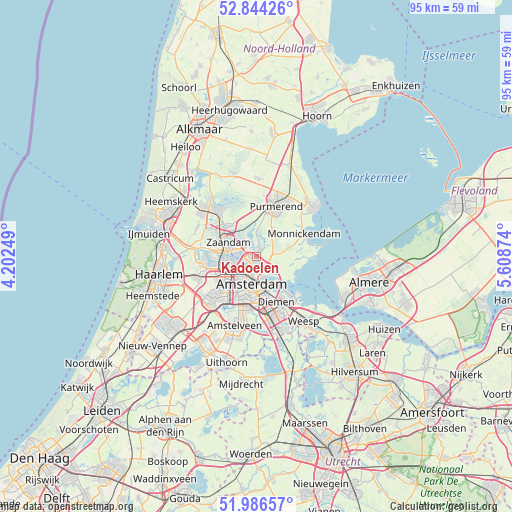
Kadoelen GPS coordinates[2]
52° 25' 3" North, 4° 54' 20.196" East
| Map corner | latitude | longitude |
|---|---|---|
| Upper-left | 52.84426°, | 4.20249° |
| Center: | 52.4175°, | 4.90561° |
| Lower-right: | 51.98657°, | 5.60874° |
| Map W x H: | 95.4×95.4 km | = 59.3×59.3mi |
| max Lat: | 53.48025° ⇑30.6% North |
| Kadoelen: | 52.4175° |
| min Lat: | ⇓69.4% South 50.76917° |
| min Long | Kadoelen | max Long |
| 3.38611° | 4.90561° | 7.16528° |
| W 23.8%⇐ | ⇒76.2% E |
Elevation
Elevation of Kadoelen is 0 m = 0 ft, and this is 15 m = 49 ft below average elevation for this country.
| Max E: |
203 m = 666 ft | 91.3% |
| Avg. | 15 m = 49 ft | |
| Kadoelen | 0 m = 0 ft | |
Min E: |
-6 m = -20 ft | 8.7% |
See also: Netherlands elevation on elevation.city.
Geographical zone
Kadoelen is located in North temperate zone (between Tropic of Cancer and the Arctic Circle). Distance of this North polar circle is 1572.9 km =977.4 mi to North.| Distance of | km | miles | from Kadoelen |
|---|---|---|---|
| North Pole | 4178.8 | 2596.6 | to North |
| Arctic Circle | 1572.9 | 977.4 | to North |
| Tropic Cancer | 3222.4 | 2002.3 | to South |
| Equator | 5828.3 | 3621.5 | to South |


Nearby cities:
15 places around Kadoelen: (largest is in red/bold)
• Amsterdam
5 km =3.1 mi,  192°
192°
• Broek in Waterland
6.4 km =4 mi,  73°
73°
• Den Ilp
4.1 km =2.5 mi,  1°
1°
• Diemen
9.5 km =5.9 mi,  155°
155°
• Duivendrecht
10.1 km =6.3 mi,  166°
166°
• Halfweg
11 km =6.8 mi,  249°
249°
• Halfweg
12 km =7.5 mi,  7°
7°
• Ilpendam
5.9 km =3.7 mi,  30°
30°
• Landsmeer
1.6 km =1 mi,  23°
23°
• Lijnden
12.4 km =7.7 mi,  234°
234°
• Monnickendam
10 km =6.2 mi,  63°
63°
• Purmerend
10.4 km =6.5 mi, 20°
• Zaandam
5.9 km =3.7 mi,  293°
293°
• Zaandijk
9.3 km =5.8 mi,  313°
313°
• Zaanstad
7.4 km =4.6 mi,  302°
302°
Sources, notices
• [Note1] Compared only with cities in Netherlands existing in our database
• [Src1] Map data: © OpenStreetMap contributors (CC-BY-SA)
• [Src2] Other city data from geonames.org with taken over terms of usage.
• [Src3] Geographical zone / Annual Mean Temperature by Robert A. Rohde @ Wikipedia
