Best geodata
Best (North Brabant) is a populated place; located in Netherlands in Europe/Amsterdam (GMT+2) time zone. With population of 29,074 people, there are 110 cities with bigger population in this country. Compared to other cities in Netherlands, 80.2% of cities are located further ↑North; 61.1% of cities are located further →East and 73.5% of cities have lower elevation than Best. Note1


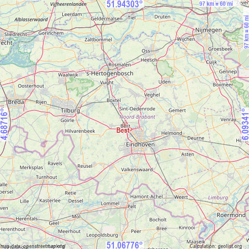
Best GPS coordinates[2]
51° 30' 27" North, 5° 23' 25.008" East
| Map corner | latitude | longitude |
|---|---|---|
| Upper-left | 51.94303°, | 4.68716° |
| Center: | 51.5075°, | 5.39028° |
| Lower-right: | 51.06776°, | 6.09341° |
| Map W x H: | 97.3×97.3 km | = 60.5×60.5mi |
| max Lat: | 53.48025° ⇑80.2% North |
| Best: | 51.5075° |
| min Lat: | ⇓19.8% South 50.76917° |
| min Long | Best | max Long |
| 3.38611° | 5.39028° | 7.16528° |
| W 38.9%⇐ | ⇒61.1% E |
Elevation
Elevation of Best is 17 m = 56 ft, and this is 2 m = 7 ft above average elevation for this country.
| Max E: |
203 m = 666 ft | 26.5% |
| Best | 17 m 56 ft | |
| Avg. | 15 m = 49 ft | |
Min E: |
-6 m = -20 ft | 73.5% |
See also: Netherlands elevation on elevation.city.
Geographical zone
Best is located in North temperate zone (between Tropic of Cancer and the Arctic Circle). Distance of this North polar circle is 1674.1 km =1040.2 mi to North.| Distance of | km | miles | from Best |
|---|---|---|---|
| North Pole | 4280 | 2659.5 | to North |
| Arctic Circle | 1674.1 | 1040.2 | to North |
| Tropic Cancer | 3121.2 | 1939.4 | to South |
| Equator | 5727.1 | 3558.7 | to South |


Nearby cities:
15 places around Best: (largest is in red/bold)
• Batadorp
2.1 km =1.3 mi,  162°
162°
• Boskant
5.2 km =3.2 mi,  24°
24°
• Grasrijk
7.8 km =4.8 mi,  167°
167°
• Heesterakker
7.7 km =4.8 mi,  107°
107°
• Jagershoef
6.5 km =4 mi,  125°
125°
• Liempde
7 km =4.3 mi,  349°
349°
• Meerhoven
7.4 km =4.6 mi, 168°
• Naastenbest
0.4 km =0.2 mi,  226°
226°
• Oirschot
5.3 km =3.3 mi,  266°
266°
• Salderes
0.8 km =0.5 mi,  358°
358°
• Son
7.1 km =4.4 mi,  86°
86°
• Son en Breugel
7.4 km =4.6 mi,  82°
82°
• Speelheide
1 km =0.6 mi,  98°
98°
• Wilhelminadorp
1.1 km =0.7 mi, 173°
• Woenselse Heide
5.9 km =3.7 mi,  116°
116°
Sources, notices
• [Note1] Compared only with cities in Netherlands existing in our database
• [Src1] Map data: © OpenStreetMap contributors (CC-BY-SA)
• [Src2] Other city data from geonames.org with taken over terms of usage.
• [Src3] Geographical zone / Annual Mean Temperature by Robert A. Rohde @ Wikipedia
