Hensbroek geodata
Hensbroek (North Holland) is a populated place; located in Netherlands in Europe/Amsterdam (GMT+2) time zone. With population of 1,345 people, there are 1214 cities with bigger population in this country. Compared to other cities in Netherlands, 74.8% of cities are located further ↓South; 76.8% of cities are located further →East and 98.2% of cities have higher elevation than Hensbroek. Note1


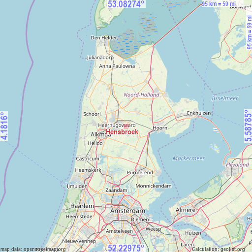
Hensbroek GPS coordinates[2]
52° 39' 29.988" North, 4° 53' 4.992" East
| Map corner | latitude | longitude |
|---|---|---|
| Upper-left | 53.08274°, | 4.1816° |
| Center: | 52.65833°, | 4.88472° |
| Lower-right: | 52.22975°, | 5.58785° |
| Map W x H: | 94.8×94.8 km | = 58.9×58.9mi |
| max Lat: | 53.48025° ⇑25.2% North |
| Hensbroek: | 52.65833° |
| min Lat: | ⇓74.8% South 50.76917° |
| min Long | Hensbroek | max Long |
| 3.38611° | 4.88472° | 7.16528° |
| W 23.2%⇐ | ⇒76.8% E |
Elevation
Elevation of Hensbroek is -2 m = -7 ft, and this is 17 m = 56 ft below average elevation for this country.
| Max E: |
203 m = 666 ft | 98.2% |
| Avg. | 15 m = 49 ft | |
| Hensbroek | -2 m = -7 ft | |
Min E: |
-6 m = -20 ft | 1.8% |
See also: Netherlands elevation on elevation.city.
Geographical zone
Hensbroek is located in North temperate zone (between Tropic of Cancer and the Arctic Circle). Distance of this North polar circle is 1546.1 km =960.7 mi to North.| Distance of | km | miles | from Hensbroek |
|---|---|---|---|
| North Pole | 4152 | 2579.9 | to North |
| Arctic Circle | 1546.1 | 960.7 | to North |
| Tropic Cancer | 3249.1 | 2018.9 | to South |
| Equator | 5855.1 | 3638.2 | to South |


Nearby cities:
15 places around Hensbroek: (largest is in red/bold)
• Avenhorn
6.4 km =4 mi,  135°
135°
• Broek op Langedijk
5.6 km =3.5 mi,  288°
288°
• De Goorn
5.6 km =3.5 mi,  130°
130°
• De Noord
5.9 km =3.7 mi,  337°
337°
• Heerhugowaard
2.8 km =1.7 mi,  300°
300°
• Hoogwoud
7.4 km =4.6 mi,  29°
29°
• Noord-Scharwoude
6.7 km =4.2 mi,  311°
311°
• Obdam
2.5 km =1.6 mi,  37°
37°
• Opmeer
6.7 km =4.2 mi, 36°
• Oterleek
4.1 km =2.5 mi,  234°
234°
• Schermerhorn
6.4 km =4 mi,  175°
175°
• Sint Pancras
6.8 km =4.2 mi,  271°
271°
• Spierdijk
4 km =2.5 mi,  101°
101°
• Stompetoren
6.6 km =4.1 mi,  220°
220°
• Zuid-Scharwoude
6 km =3.7 mi, 301°
Sources, notices
• [Note1] Compared only with cities in Netherlands existing in our database
• [Src1] Map data: © OpenStreetMap contributors (CC-BY-SA)
• [Src2] Other city data from geonames.org with taken over terms of usage.
• [Src3] Geographical zone / Annual Mean Temperature by Robert A. Rohde @ Wikipedia
