Obdam geodata
Obdam (North Holland) is a populated place; located in Netherlands in Europe/Amsterdam (GMT+2) time zone. With population of 5,690 people, there are 428 cities with bigger population in this country. Compared to other cities in Netherlands, 75.9% of cities are located further ↓South; 76.2% of cities are located further →East and 83.9% of cities have higher elevation than Obdam. Note1


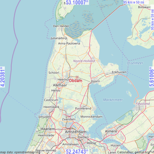
Obdam GPS coordinates[2]
52° 40' 32.988" North, 4° 54' 24.984" East
| Map corner | latitude | longitude |
|---|---|---|
| Upper-left | 53.10007°, | 4.20381° |
| Center: | 52.67583°, | 4.90694° |
| Lower-right: | 52.24743°, | 5.61006° |
| Map W x H: | 94.8×94.8 km | = 58.9×58.9mi |
| max Lat: | 53.48025° ⇑24.1% North |
| Obdam: | 52.67583° |
| min Lat: | ⇓75.9% South 50.76917° |
| min Long | Obdam | max Long |
| 3.38611° | 4.90694° | 7.16528° |
| W 23.8%⇐ | ⇒76.2% E |
Elevation
Elevation of Obdam is 1 m = 3 ft, and this is 14 m = 46 ft below average elevation for this country.
| Max E: |
203 m = 666 ft | 83.9% |
| Avg. | 15 m = 49 ft | |
| Obdam | 1 m = 3 ft | |
Min E: |
-6 m = -20 ft | 16.1% |
See also: Netherlands elevation on elevation.city.
Geographical zone
Obdam is located in North temperate zone (between Tropic of Cancer and the Arctic Circle). Distance of this North polar circle is 1544.2 km =959.5 mi to North.| Distance of | km | miles | from Obdam |
|---|---|---|---|
| North Pole | 4150.1 | 2578.8 | to North |
| Arctic Circle | 1544.2 | 959.5 | to North |
| Tropic Cancer | 3251.1 | 2020.1 | to South |
| Equator | 5857 | 3639.4 | to South |


Nearby cities:
15 places around Obdam: (largest is in red/bold)
• Avenhorn
7.1 km =4.4 mi,  155°
155°
• Berkhout
7.5 km =4.7 mi,  121°
121°
• Broek op Langedijk
6.8 km =4.2 mi,  268°
268°
• De Goorn
6.2 km =3.9 mi,  153°
153°
• De Noord
5.1 km =3.2 mi,  313°
313°
• Heerhugowaard
4 km =2.5 mi,  262°
262°
• Hensbroek
2.5 km =1.6 mi,  217°
217°
• Hoogwoud
4.9 km =3 mi,  25°
25°
• Nieuwe-Niedorp
7.2 km =4.5 mi,  355°
355°
• Noord-Scharwoude
6.9 km =4.3 mi,  291°
291°
• Opmeer
4.3 km =2.7 mi,  36°
36°
• Oterleek
6.5 km =4 mi,  228°
228°
• Spierdijk
3.7 km =2.3 mi,  138°
138°
• Waarland
7.6 km =4.7 mi,  318°
318°
• Zuid-Scharwoude
6.8 km =4.2 mi,  280°
280°
Sources, notices
• [Note1] Compared only with cities in Netherlands existing in our database
• [Src1] Map data: © OpenStreetMap contributors (CC-BY-SA)
• [Src2] Other city data from geonames.org with taken over terms of usage.
• [Src3] Geographical zone / Annual Mean Temperature by Robert A. Rohde @ Wikipedia
