Amersfoort geodata
Amersfoort (Utrecht) is a populated place; located in Netherlands in Europe/Amsterdam (GMT+2) time zone. With population of 139,914 people, there are 14 cities with bigger population in this country. Compared to other cities in Netherlands, 57.2% of cities are located further ↓South; 61.3% of cities are located further →East and 55.1% of cities have lower elevation than Amersfoort. Note1


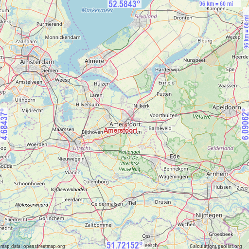
Amersfoort GPS coordinates[2]
52° 9' 18" North, 5° 23' 15" East
| Map corner | latitude | longitude |
|---|---|---|
| Upper-left | 52.5843°, | 4.68437° |
| Center: | 52.155°, | 5.3875° |
| Lower-right: | 51.72152°, | 6.09062° |
| Map W x H: | 95.9×95.9 km | = 59.6×59.6mi |
| max Lat: | 53.48025° ⇑42.8% North |
| Amersfoort: | 52.155° |
| min Lat: | ⇓57.2% South 50.76917° |
| min Long | Amersfoort | max Long |
| 3.38611° | 5.3875° | 7.16528° |
| W 38.7%⇐ | ⇒61.3% E |
Elevation
Elevation of Amersfoort is 8 m = 26 ft, and this is 7 m = 23 ft below average elevation for this country.
| Max E: |
203 m = 666 ft | 44.9% |
| Avg. | 15 m = 49 ft | |
| Amersfoort | 8 m = 26 ft | |
Min E: |
-6 m = -20 ft | 55.1% |
See also: Amersfoort elevation on elevation.city.
Geographical zone
Amersfoort is located in North temperate zone (between Tropic of Cancer and the Arctic Circle). Distance of this North polar circle is 1602.1 km =995.5 mi to North.| Distance of | km | miles | from Amersfoort |
|---|---|---|---|
| North Pole | 4208 | 2614.7 | to North |
| Arctic Circle | 1602.1 | 995.5 | to North |
| Tropic Cancer | 3193.2 | 1984.2 | to South |
| Equator | 5799.1 | 3603.4 | to South |


Nearby cities:
15 places around Amersfoort: (largest is in red/bold)
• Austerlitz
9.7 km =6 mi,  210°
210°
• Baarn
9.3 km =5.8 mi,  312°
312°
• Corlaer
8.6 km =5.3 mi,  37°
37°
• Doornsteeg
9.5 km =5.9 mi,  28°
28°
• Hoogland
3.2 km =2 mi,  342°
342°
• Langenoord
3.7 km =2.3 mi,  352°
352°
• Leusden
3.9 km =2.4 mi,  129°
129°
• Nijkerkerveen
7 km =4.3 mi,  50°
50°
• Randenbroek
1.2 km =0.7 mi, 127°
• Soest
6.8 km =4.2 mi,  287°
287°
• Soestdijk
8.1 km =5 mi,  299°
299°
• Sterrenberg
8.5 km =5.3 mi,  237°
237°
• Terschuur
8.9 km =5.5 mi,  82°
82°
• Woudenberg
8.5 km =5.3 mi,  166°
166°
• Zwartebroek
8.4 km =5.2 mi,  71°
71°
Sources, notices
• [Note1] Compared only with cities in Netherlands existing in our database
• [Src1] Map data: © OpenStreetMap contributors (CC-BY-SA)
• [Src2] Other city data from geonames.org with taken over terms of usage.
• [Src3] Geographical zone / Annual Mean Temperature by Robert A. Rohde @ Wikipedia
