Bunschoten geodata
Bunschoten (Utrecht) is a populated place; located in Netherlands in Europe/Amsterdam (GMT+2) time zone. With population of 3,015 people, there are 753 cities with bigger population in this country. Compared to other cities in Netherlands, 63.9% of cities are located further ↓South; 61.5% of cities are located further →East and 91.3% of cities have higher elevation than Bunschoten. Note1


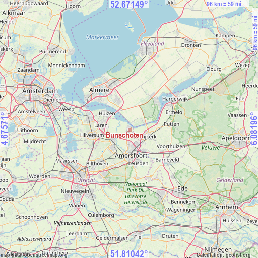
Bunschoten GPS coordinates[2]
52° 14' 34.944" North, 5° 22' 43.824" East
| Map corner | latitude | longitude |
|---|---|---|
| Upper-left | 52.67149°, | 4.67571° |
| Center: | 52.24304°, | 5.37884° |
| Lower-right: | 51.81042°, | 6.08196° |
| Map W x H: | 95.7×95.7 km | = 59.5×59.5mi |
| max Lat: | 53.48025° ⇑36.1% North |
| Bunschoten: | 52.24304° |
| min Lat: | ⇓63.9% South 50.76917° |
| min Long | Bunschoten | max Long |
| 3.38611° | 5.37884° | 7.16528° |
| W 38.5%⇐ | ⇒61.5% E |
Elevation
Elevation of Bunschoten is 0 m = 0 ft, and this is 15 m = 49 ft below average elevation for this country.
| Max E: |
203 m = 666 ft | 91.3% |
| Avg. | 15 m = 49 ft | |
| Bunschoten | 0 m = 0 ft | |
Min E: |
-6 m = -20 ft | 8.7% |
See also: Netherlands elevation on elevation.city.
Geographical zone
Bunschoten is located in North temperate zone (between Tropic of Cancer and the Arctic Circle). Distance of this North polar circle is 1592.3 km =989.4 mi to North.| Distance of | km | miles | from Bunschoten |
|---|---|---|---|
| North Pole | 4198.2 | 2608.6 | to North |
| Arctic Circle | 1592.3 | 989.4 | to North |
| Tropic Cancer | 3203 | 1990.3 | to South |
| Equator | 5808.9 | 3609.5 | to South |


Nearby cities:
15 places around Bunschoten: (largest is in red/bold)
• Amersfoort
9.8 km =6.1 mi,  176°
176°
• Baarn
7.1 km =4.4 mi,  240°
240°
• Bijvanck
9.1 km =5.7 mi,  301°
301°
• Blaricum
9.9 km =6.2 mi,  289°
289°
• Corlaer
6.6 km =4.1 mi,  116°
116°
• Doornsteeg
5.3 km =3.3 mi,  105°
105°
• Eemdijk
3.5 km =2.2 mi, 292°
• Eemnes
8.1 km =5 mi,  278°
278°
• Hoogland
6.7 km =4.2 mi, 183°
• Langenoord
6.2 km =3.9 mi, 179°
• Nijkerk
7.7 km =4.8 mi, 109°
• Nijkerkerveen
8 km =5 mi,  131°
131°
• Soest
9.8 km =6.1 mi,  217°
217°
• Soestdijk
8.6 km =5.3 mi,  227°
227°
• Spakenburg
1.1 km =0.7 mi,  313°
313°
Sources, notices
• [Note1] Compared only with cities in Netherlands existing in our database
• [Src1] Map data: © OpenStreetMap contributors (CC-BY-SA)
• [Src2] Other city data from geonames.org with taken over terms of usage.
• [Src3] Geographical zone / Annual Mean Temperature by Robert A. Rohde @ Wikipedia
