Steinkjer geodata
Steinkjer (Trøndelag) is a seat of a first-order administrative division; located in Norway in Europe/Oslo (GMT+2) time zone. With population of 20,000 people, there are 24 cities with bigger population in this country. Compared to other cities in Norway, 79.9% of cities are located further ↓South; 78% of cities are located further ←West and 69% of cities have higher elevation than Steinkjer. Note1


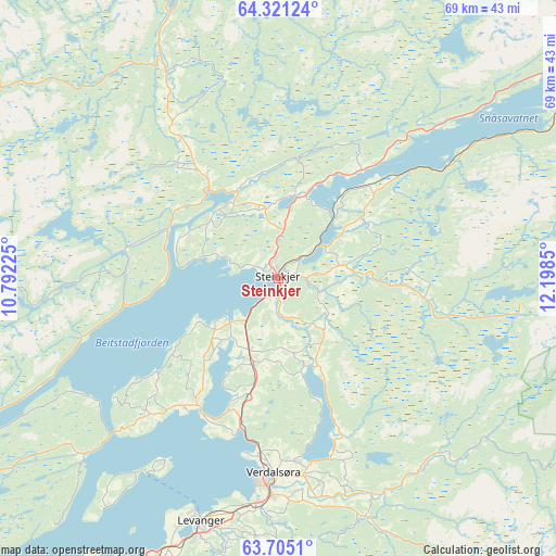
Steinkjer GPS coordinates[2]
64° 0' 53.532" North, 11° 29' 43.332" East
| Map corner | latitude | longitude |
|---|---|---|
| Upper-left | 64.32124°, | 10.79225° |
| Center: | 64.01487°, | 11.49537° |
| Lower-right: | 63.7051°, | 12.1985° |
| Map W x H: | 68.5×68.5 km | = 42.6×42.6mi |
| max Lat: | 71.04137° ⇑20.1% North |
| Steinkjer: | 64.01487° |
| min Lat: | ⇓79.9% South 58.0274° |
| min Long | Steinkjer | max Long |
| 4.71485° | 11.49537° | 31.11066° |
| W 78%⇐ | ⇒22% E |
Elevation
Elevation of Steinkjer is 20 m = 66 ft, and this is 84.2 m = 276 ft below average elevation for this country.
| Max E: |
897 m = 2943 ft | 69% |
| Avg. | 104.2 m = 342 ft | |
| Steinkjer | 20 m = 66 ft | |
Min E: |
1 m = 3 ft | 31% |
See also: Norway elevation on elevation.city.
Geographical zone
Steinkjer is located in North temperate zone (between Tropic of Cancer and the Arctic Circle). Distance of this North polar circle is 283.4 km =176.1 mi to North.| Distance of | km | miles | from Steinkjer |
|---|---|---|---|
| North Pole | 2889.3 | 1795.3 | to North |
| Arctic Circle | 283.4 | 176.1 | to North |
| Tropic Cancer | 4511.9 | 2803.6 | to South |
| Equator | 7117.8 | 4422.8 | to South |


Nearby cities:
15 places around Steinkjer: (largest is in red/bold)
• Bangsund
42.2 km =26.2 mi,  353°
353°
• Frosta
60.1 km =37.3 mi,  217°
217°
• Leksvik
57.2 km =35.5 mi,  228°
228°
• Levanger
31.3 km =19.4 mi,  197°
197°
• Malm
14.8 km =9.2 mi,  296°
296°
• Namdalseid
26.5 km =16.5 mi,  330°
330°
• Namsos
50.2 km =31.2 mi,  0°
0°
• Ranemsletta
57.7 km =35.9 mi,  22°
22°
• Skage
51.9 km =32.2 mi,  14°
14°
• Skogn
37.6 km =23.4 mi, 203°
• Snåase
49.9 km =31 mi,  59°
59°
• Sparbu
11.1 km =6.9 mi, 195°
• Steinsdalen
57.1 km =35.5 mi, 303°
• Straumen
18.7 km =11.6 mi,  211°
211°
• Verdal
24.6 km =15.3 mi,  181°
181°
Sources, notices
• [Note1] Compared only with cities in Norway existing in our database
• [Src1] Map data: © OpenStreetMap contributors (CC-BY-SA)
• [Src2] Other city data from geonames.org with taken over terms of usage.
• [Src3] Geographical zone / Annual Mean Temperature by Robert A. Rohde @ Wikipedia
