Skjærhalden geodata
Skjærhalden (Østfold) is a seat of a second-order administrative division; located in Norway in Europe/Oslo (GMT+2) time zone. With population of 642 people, there are 402 cities with bigger population in this country. Compared to other cities in Norway, 89.6% of cities are located further ↑North; 68% of cities are located further ←West and 88.6% of cities have higher elevation than Skjærhalden. Note1


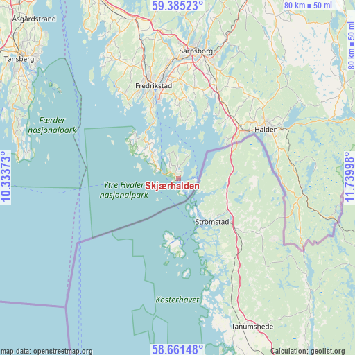
Skjærhalden GPS coordinates[2]
59° 1' 30.936" North, 11° 2' 12.66" East
| Map corner | latitude | longitude |
|---|---|---|
| Upper-left | 59.38523°, | 10.33373° |
| Center: | 59.02526°, | 11.03685° |
| Lower-right: | 58.66148°, | 11.73998° |
| Map W x H: | 80.5×80.5 km | = 50×50mi |
| max Lat: | 71.04137° ⇑89.6% North |
| Skjærhalden: | 59.02526° |
| min Lat: | ⇓10.4% South 58.0274° |
| min Long | Skjærhalden | max Long |
| 4.71485° | 11.03685° | 31.11066° |
| W 68%⇐ | ⇒32% E |
Elevation
Elevation of Skjærhalden is 5 m = 16 ft, and this is 99.2 m = 325 ft below average elevation for this country.
| Max E: |
897 m = 2943 ft | 88.6% |
| Avg. | 104.2 m = 342 ft | |
| Skjærhalden | 5 m = 16 ft | |
Min E: |
1 m = 3 ft | 11.4% |
See also: Norway elevation on elevation.city.
Geographical zone
Skjærhalden is located in North temperate zone (between Tropic of Cancer and the Arctic Circle). Distance of this North polar circle is 838.2 km =520.8 mi to North.| Distance of | km | miles | from Skjærhalden |
|---|---|---|---|
| North Pole | 3444.1 | 2140.1 | to North |
| Arctic Circle | 838.2 | 520.8 | to North |
| Tropic Cancer | 3957.1 | 2458.8 | to South |
| Equator | 6563 | 4078.1 | to South |


Nearby cities:
15 places around Skjærhalden: (largest is in red/bold)
• Borgheim
42.3 km =26.3 mi,  301°
301°
• Fossby
43.7 km =27.2 mi,  59°
59°
• Fredrikstad
22.3 km =13.9 mi,  344°
344°
• Halden
22.9 km =14.2 mi, 61°
• Ise
32.3 km =20.1 mi,  18°
18°
• Karlshus
37.5 km =23.3 mi,  345°
345°
• Larkollen
40.1 km =24.9 mi,  328°
328°
• Lervik
32 km =19.9 mi, 328°
• Rygge
42.4 km =26.3 mi, 337°
• Ryggebyen
42.2 km =26.2 mi, 337°
• Sarpsborg
29.1 km =18.1 mi,  8°
8°
• Skjeberg
22.5 km =14 mi, 22°
• Slevik
22.5 km =14 mi, 327°
• Tjøme
38 km =23.6 mi,  284°
284°
• Årøysund
37.5 km =23.3 mi, 297°
Sources, notices
• [Note1] Compared only with cities in Norway existing in our database
• [Src1] Map data: © OpenStreetMap contributors (CC-BY-SA)
• [Src2] Other city data from geonames.org with taken over terms of usage.
• [Src3] Geographical zone / Annual Mean Temperature by Robert A. Rohde @ Wikipedia
