Odda geodata
Odda (Hordaland) is a seat of a second-order administrative division; located in Norway in Europe/Oslo (GMT+2) time zone. With population of 5,359 people, there are 87 cities with bigger population in this country. Compared to other cities in Norway, 63% of cities are located further ↑North; 78.2% of cities are located further →East and 53.3% of cities have lower elevation than Odda. Note1


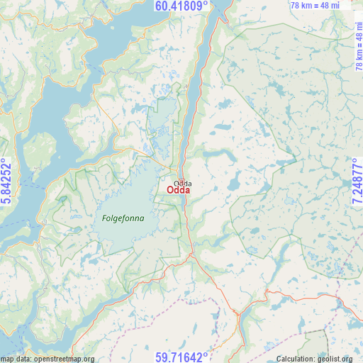
Odda GPS coordinates[2]
60° 4' 8.832" North, 6° 32' 44.34" East
| Map corner | latitude | longitude |
|---|---|---|
| Upper-left | 60.41809°, | 5.84252° |
| Center: | 60.06912°, | 6.54565° |
| Lower-right: | 59.71642°, | 7.24877° |
| Map W x H: | 78×78 km | = 48.5×48.5mi |
| max Lat: | 71.04137° ⇑63% North |
| Odda: | 60.06912° |
| min Lat: | ⇓37% South 58.0274° |
| min Long | Odda | max Long |
| 4.71485° | 6.54565° | 31.11066° |
| W 21.8%⇐ | ⇒78.2% E |
Elevation
Elevation of Odda is 53 m = 174 ft, and this is 51.2 m = 168 ft below average elevation for this country.
| Max E: |
897 m = 2943 ft | 46.7% |
| Avg. | 104.2 m = 342 ft | |
| Odda | 53 m = 174 ft | |
Min E: |
1 m = 3 ft | 53.3% |
See also: Norway elevation on elevation.city.
Geographical zone
Odda is located in North temperate zone (between Tropic of Cancer and the Arctic Circle). Distance of this North polar circle is 722.1 km =448.7 mi to North.| Distance of | km | miles | from Odda |
|---|---|---|---|
| North Pole | 3328 | 2067.9 | to North |
| Arctic Circle | 722.1 | 448.7 | to North |
| Tropic Cancer | 4073.1 | 2530.9 | to South |
| Equator | 6679.1 | 4150.2 | to South |


Nearby cities:
15 places around Odda: (largest is in red/bold)
• Eidfjord
53 km =32.9 mi,  33°
33°
• Eikelandsosen
48.3 km =30 mi,  293°
293°
• Granvin
51.5 km =32 mi,  10°
10°
• Indre Ålvik
40.9 km =25.4 mi,  351°
351°
• Jondal
28.1 km =17.5 mi,  324°
324°
• Kinsarvik
35.4 km =22 mi,  15°
15°
• Lofthus
30 km =18.6 mi, 12°
• Norheimsund
40.2 km =25 mi,  326°
326°
• Rosendal
31.1 km =19.3 mi,  252°
252°
• Sauda
47.7 km =29.6 mi,  192°
192°
• Skånevik
50.5 km =31.4 mi,  222°
222°
• Tysse
55.1 km =34.2 mi,  307°
307°
• Tyssedal
5.3 km =3.3 mi, 8°
• Uskedalen
40.8 km =25.4 mi, 248°
• Øystese
40.5 km =25.2 mi, 331°
Sources, notices
• [Note1] Compared only with cities in Norway existing in our database
• [Src1] Map data: © OpenStreetMap contributors (CC-BY-SA)
• [Src2] Other city data from geonames.org with taken over terms of usage.
• [Src3] Geographical zone / Annual Mean Temperature by Robert A. Rohde @ Wikipedia
