Røros geodata
Røros (Trøndelag) is a seat of a second-order administrative division; located in Norway in Europe/Oslo (GMT+2) time zone. With population of 3,496 people, there are 118 cities with bigger population in this country. Compared to other cities in Norway, 69.1% of cities are located further ↓South; 76.3% of cities are located further ←West and 98.7% of cities have lower elevation than Røros. Note1


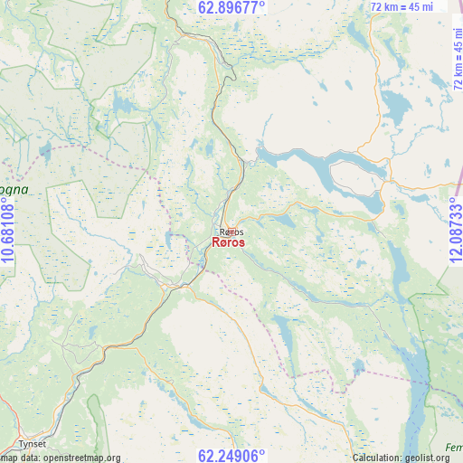
Røros GPS coordinates[2]
62° 34' 28.848" North, 11° 23' 3.12" East
| Map corner | latitude | longitude |
|---|---|---|
| Upper-left | 62.89677°, | 10.68108° |
| Center: | 62.57468°, | 11.3842° |
| Lower-right: | 62.24906°, | 12.08733° |
| Map W x H: | 72×72 km | = 44.7×44.7mi |
| max Lat: | 71.04137° ⇑30.9% North |
| Røros: | 62.57468° |
| min Lat: | ⇓69.1% South 58.0274° |
| min Long | Røros | max Long |
| 4.71485° | 11.3842° | 31.11066° |
| W 76.3%⇐ | ⇒23.7% E |
Elevation
Elevation of Røros is 640 m = 2100 ft, and this is 535.8 m = 1758 ft above average elevation for this country.
| Max E: |
897 m = 2943 ft | 1.3% |
| Røros | 640 m 2100 ft | |
| Avg. | 104.2 m = 342 ft | |
Min E: |
1 m = 3 ft | 98.7% |
See also: Norway elevation on elevation.city.
Geographical zone
Røros is located in North temperate zone (between Tropic of Cancer and the Arctic Circle). Distance of this North polar circle is 443.5 km =275.6 mi to North.| Distance of | km | miles | from Røros |
|---|---|---|---|
| North Pole | 3049.4 | 1894.8 | to North |
| Arctic Circle | 443.5 | 275.6 | to North |
| Tropic Cancer | 4351.7 | 2704 | to South |
| Equator | 6957.7 | 4323.3 | to South |


Nearby cities:
15 places around Røros: (largest is in red/bold)
• Aas
54.5 km =33.9 mi,  14°
14°
• Alvdal
64.9 km =40.3 mi,  216°
216°
• Bergset
77.6 km =48.2 mi,  191°
191°
• Berkåk
75.3 km =46.8 mi,  291°
291°
• Folldal
86.8 km =53.9 mi,  235°
235°
• Hovin
83.4 km =51.8 mi,  315°
315°
• Klæbu
92.4 km =57.4 mi,  330°
330°
• Lundamo
85 km =52.8 mi, 319°
• Mebonden
75.1 km =46.7 mi,  346°
346°
• Oppdal
86.7 km =53.9 mi,  271°
271°
• Os
12 km =7.5 mi, 223°
• Støren
76.1 km =47.3 mi,  312°
312°
• Tolga
27 km =16.8 mi,  227°
227°
• Tynset
45.4 km =28.2 mi, 222°
• Ålen
30 km =18.6 mi, 351°
Sources, notices
• [Note1] Compared only with cities in Norway existing in our database
• [Src1] Map data: © OpenStreetMap contributors (CC-BY-SA)
• [Src2] Other city data from geonames.org with taken over terms of usage.
• [Src3] Geographical zone / Annual Mean Temperature by Robert A. Rohde @ Wikipedia
