Folldal geodata
Folldal (Hedmark) is a seat of a second-order administrative division; located in Norway in Europe/Oslo (GMT+2) time zone. With population of 586 people, there are 425 cities with bigger population in this country. Compared to other cities in Norway, 65% of cities are located further ↓South; 51.6% of cities are located further →East and 99.2% of cities have lower elevation than Folldal. Note1


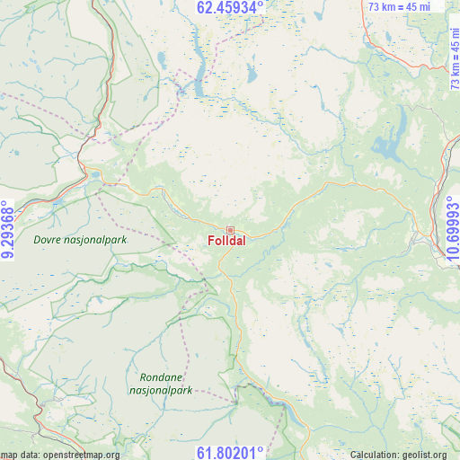
Folldal GPS coordinates[2]
62° 7' 56.856" North, 9° 59' 48.48" East
| Map corner | latitude | longitude |
|---|---|---|
| Upper-left | 62.45934°, | 9.29368° |
| Center: | 62.13246°, | 9.9968° |
| Lower-right: | 61.80201°, | 10.69993° |
| Map W x H: | 73.1×73.1 km | = 45.4×45.4mi |
| max Lat: | 71.04137° ⇑35% North |
| Folldal: | 62.13246° |
| min Lat: | ⇓65% South 58.0274° |
| min Long | Folldal | max Long |
| 4.71485° | 9.9968° | 31.11066° |
| W 48.4%⇐ | ⇒51.6% E |
Elevation
Elevation of Folldal is 700 m = 2297 ft, and this is 595.8 m = 1955 ft above average elevation for this country.
| Max E: |
897 m = 2943 ft | 0.8% |
| Folldal | 700 m 2297 ft | |
| Avg. | 104.2 m = 342 ft | |
Min E: |
1 m = 3 ft | 99.2% |
See also: Norway elevation on elevation.city.
Geographical zone
Folldal is located in North temperate zone (between Tropic of Cancer and the Arctic Circle). Distance of this North polar circle is 492.7 km =306.1 mi to North.| Distance of | km | miles | from Folldal |
|---|---|---|---|
| North Pole | 3098.6 | 1925.4 | to North |
| Arctic Circle | 492.7 | 306.1 | to North |
| Tropic Cancer | 4302.6 | 2673.5 | to South |
| Equator | 6908.5 | 4292.7 | to South |


Nearby cities:
15 places around Folldal: (largest is in red/bold)
• Alvdal
33.1 km =20.6 mi,  94°
94°
• Bergset
62.5 km =38.8 mi,  115°
115°
• Dale
47.6 km =29.6 mi,  213°
213°
• Dombås
45.6 km =28.3 mi,  262°
262°
• Dovre
41.8 km =26 mi,  247°
247°
• Hundorp
64.2 km =39.9 mi,  182°
182°
• Kvam
54.4 km =33.8 mi,  197°
197°
• Lesja
58.9 km =36.6 mi,  268°
268°
• Oppdal
53.7 km =33.4 mi,  342°
342°
• Otta
46.9 km =29.1 mi, 210°
• Ringebu
67.4 km =41.9 mi,  173°
173°
• Tolga
60.3 km =37.5 mi,  59°
59°
• Tynset
43.7 km =27.2 mi,  68°
68°
• Vinstra
61.1 km =38 mi,  192°
192°
• Vågåmo
55 km =34.2 mi,  238°
238°
Sources, notices
• [Note1] Compared only with cities in Norway existing in our database
• [Src1] Map data: © OpenStreetMap contributors (CC-BY-SA)
• [Src2] Other city data from geonames.org with taken over terms of usage.
• [Src3] Geographical zone / Annual Mean Temperature by Robert A. Rohde @ Wikipedia
