Oppdal geodata
Oppdal (Trøndelag) is a seat of a second-order administrative division; located in Norway in Europe/Oslo (GMT+2) time zone. With population of 6,976 people, there are 64 cities with bigger population in this country. Compared to other cities in Norway, 69.6% of cities are located further ↓South; 54.1% of cities are located further →East and 97.9% of cities have lower elevation than Oppdal. Note1


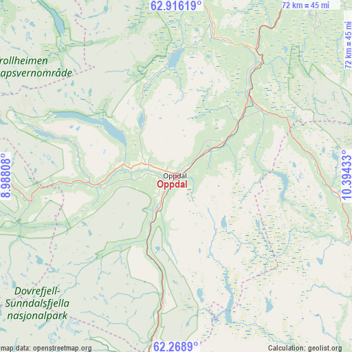
Oppdal GPS coordinates[2]
62° 35' 39.516" North, 9° 41' 28.32" East
| Map corner | latitude | longitude |
|---|---|---|
| Upper-left | 62.91619°, | 8.98808° |
| Center: | 62.59431°, | 9.6912° |
| Lower-right: | 62.2689°, | 10.39433° |
| Map W x H: | 72×72 km | = 44.7×44.7mi |
| max Lat: | 71.04137° ⇑30.4% North |
| Oppdal: | 62.59431° |
| min Lat: | ⇓69.6% South 58.0274° |
| min Long | Oppdal | max Long |
| 4.71485° | 9.6912° | 31.11066° |
| W 45.9%⇐ | ⇒54.1% E |
Elevation
Elevation of Oppdal is 550 m = 1804 ft, and this is 445.8 m = 1463 ft above average elevation for this country.
| Max E: |
897 m = 2943 ft | 2.1% |
| Oppdal | 550 m 1804 ft | |
| Avg. | 104.2 m = 342 ft | |
Min E: |
1 m = 3 ft | 97.9% |
See also: Norway elevation on elevation.city.
Geographical zone
Oppdal is located in North temperate zone (between Tropic of Cancer and the Arctic Circle). Distance of this North polar circle is 441.3 km =274.2 mi to North.| Distance of | km | miles | from Oppdal |
|---|---|---|---|
| North Pole | 3047.2 | 1893.4 | to North |
| Arctic Circle | 441.3 | 274.2 | to North |
| Tropic Cancer | 4353.9 | 2705.4 | to South |
| Equator | 6959.8 | 4324.6 | to South |


Nearby cities:
15 places around Oppdal: (largest is in red/bold)
• Berkåk
30.4 km =18.9 mi,  32°
32°
• Dombås
64.6 km =40.1 mi,  206°
206°
• Folldal
53.7 km =33.4 mi,  162°
162°
• Grøa
49.7 km =30.9 mi,  276°
276°
• Hovin
62.9 km =39.1 mi, 25°
• Lesja
68 km =42.3 mi,  218°
218°
• Lundamo
69 km =42.9 mi, 25°
• Løkken Verk
59.1 km =36.7 mi,  0°
0°
• Meldal
50.4 km =31.3 mi, 1°
• Rindal
56.8 km =35.3 mi,  334°
334°
• Støren
57.9 km =36 mi, 31°
• Sunndalsøra
58.3 km =36.2 mi, 278°
• Surnadal
64.8 km =40.3 mi,  310°
310°
• Tolga
70.2 km =43.6 mi,  107°
107°
• Tynset
66.4 km =41.3 mi,  122°
122°
Sources, notices
• [Note1] Compared only with cities in Norway existing in our database
• [Src1] Map data: © OpenStreetMap contributors (CC-BY-SA)
• [Src2] Other city data from geonames.org with taken over terms of usage.
• [Src3] Geographical zone / Annual Mean Temperature by Robert A. Rohde @ Wikipedia
