Rødberg geodata
Rødberg (Buskerud) is a seat of a second-order administrative division; located in Norway in Europe/Oslo (GMT+2) time zone. In our database, there are 488 cities with bigger population. Compared to other cities in Norway, 57.6% of cities are located further ↑North; 60.3% of cities are located further →East and 96.8% of cities have lower elevation than Rødberg. Note1


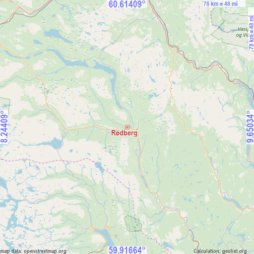
Rødberg GPS coordinates[2]
60° 16' 1.992" North, 8° 56' 49.956" East
| Map corner | latitude | longitude |
|---|---|---|
| Upper-left | 60.61409°, | 8.24409° |
| Center: | 60.26722°, | 8.94721° |
| Lower-right: | 59.91664°, | 9.65034° |
| Map W x H: | 77.5×77.5 km | = 48.2×48.2mi |
| max Lat: | 71.04137° ⇑57.6% North |
| Rødberg: | 60.26722° |
| min Lat: | ⇓42.4% South 58.0274° |
| min Long | Rødberg | max Long |
| 4.71485° | 8.94721° | 31.11066° |
| W 39.7%⇐ | ⇒60.3% E |
Elevation
Elevation of Rødberg is 477 m = 1565 ft, and this is 372.8 m = 1223 ft above average elevation for this country.
| Max E: |
897 m = 2943 ft | 3.2% |
| Rødberg | 477 m 1565 ft | |
| Avg. | 104.2 m = 342 ft | |
Min E: |
1 m = 3 ft | 96.8% |
See also: Norway elevation on elevation.city.
Geographical zone
Rødberg is located in North temperate zone (between Tropic of Cancer and the Arctic Circle). Distance of this North polar circle is 700.1 km =435 mi to North.| Distance of | km | miles | from Rødberg |
|---|---|---|---|
| North Pole | 3306 | 2054.3 | to North |
| Arctic Circle | 700.1 | 435 | to North |
| Tropic Cancer | 4095.2 | 2544.6 | to South |
| Equator | 6701.1 | 4163.9 | to South |


Nearby cities:
15 places around Rødberg: (largest is in red/bold)
• Flå
33.6 km =20.9 mi,  57°
57°
• Geilo
50.4 km =31.3 mi,  306°
306°
• Gol
48.3 km =30 mi,  359°
359°
• Hallingby
68.2 km =42.4 mi,  89°
89°
• Hol
52.7 km =32.7 mi,  317°
317°
• Lampeland
59.5 km =37 mi,  143°
143°
• Nesbyen
34.5 km =21.4 mi,  14°
14°
• Noresund
38.6 km =24 mi,  104°
104°
• Prestfoss
45.5 km =28.3 mi,  123°
123°
• Rjukan
47.4 km =29.5 mi,  204°
204°
• Rollag
36.9 km =22.9 mi,  148°
148°
• Sokna
54.2 km =33.7 mi, 93°
• Tyristrand
66.7 km =41.4 mi,  107°
107°
• Vikersund
66.7 km =41.4 mi, 119°
• Ål
45.6 km =28.3 mi,  332°
332°
Sources, notices
• [Note1] Compared only with cities in Norway existing in our database
• [Src1] Map data: © OpenStreetMap contributors (CC-BY-SA)
• [Src2] Other city data from geonames.org with taken over terms of usage.
• [Src3] Geographical zone / Annual Mean Temperature by Robert A. Rohde @ Wikipedia
