Noresund geodata
Noresund (Buskerud) is a seat of a second-order administrative division; located in Norway in Europe/Oslo (GMT+2) time zone. With population of 330 people, there are 479 cities with bigger population in this country. Compared to other cities in Norway, 60.6% of cities are located further ↑North; 55.2% of cities are located further →East and 77.4% of cities have lower elevation than Noresund. Note1


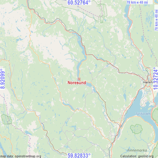
Noresund GPS coordinates[2]
60° 10' 47.46" North, 9° 37' 26.796" East
| Map corner | latitude | longitude |
|---|---|---|
| Upper-left | 60.52764°, | 8.92099° |
| Center: | 60.17985°, | 9.62411° |
| Lower-right: | 59.82833°, | 10.32724° |
| Map W x H: | 77.8×77.8 km | = 48.3×48.3mi |
| max Lat: | 71.04137° ⇑60.6% North |
| Noresund: | 60.17985° |
| min Lat: | ⇓39.4% South 58.0274° |
| min Long | Noresund | max Long |
| 4.71485° | 9.62411° | 31.11066° |
| W 44.8%⇐ | ⇒55.2% E |
Elevation
Elevation of Noresund is 160 m = 525 ft, and this is 55.8 m = 183 ft above average elevation for this country.
| Max E: |
897 m = 2943 ft | 22.6% |
| Noresund | 160 m 525 ft | |
| Avg. | 104.2 m = 342 ft | |
Min E: |
1 m = 3 ft | 77.4% |
See also: Norway elevation on elevation.city.
Geographical zone
Noresund is located in North temperate zone (between Tropic of Cancer and the Arctic Circle). Distance of this North polar circle is 709.8 km =441 mi to North.| Distance of | km | miles | from Noresund |
|---|---|---|---|
| North Pole | 3315.7 | 2060.3 | to North |
| Arctic Circle | 709.8 | 441 | to North |
| Tropic Cancer | 4085.5 | 2538.6 | to South |
| Equator | 6691.4 | 4157.8 | to South |


Nearby cities:
15 places around Noresund: (largest is in red/bold)
• Flå
29.2 km =18.1 mi,  342°
342°
• Hallingby
32.6 km =20.3 mi,  71°
71°
• Hokksund
48.2 km =30 mi,  160°
160°
• Hønefoss
35 km =21.7 mi,  92°
92°
• Jevnaker
42.7 km =26.5 mi,  81°
81°
• Lampeland
38.4 km =23.9 mi,  183°
183°
• Prestfoss
15.2 km =9.4 mi, 177°
• Rollag
28.3 km =17.6 mi,  219°
219°
• Rødberg
38.6 km =24 mi,  284°
284°
• Sokna
18 km =11.2 mi, 68°
• Sundvollen
40 km =24.9 mi,  108°
108°
• Sylling
48.9 km =30.4 mi,  130°
130°
• Tyristrand
28.2 km =17.5 mi, 111°
• Vik
38 km =23.6 mi, 107°
• Vikersund
31.1 km =19.3 mi,  139°
139°
Sources, notices
• [Note1] Compared only with cities in Norway existing in our database
• [Src1] Map data: © OpenStreetMap contributors (CC-BY-SA)
• [Src2] Other city data from geonames.org with taken over terms of usage.
• [Src3] Geographical zone / Annual Mean Temperature by Robert A. Rohde @ Wikipedia
