Indre Ålvik geodata
Indre Ålvik (Hordaland) is a populated place; located in Norway in Europe/Oslo (GMT+2) time zone. With population of 592 people, there are 421 cities with bigger population in this country. Compared to other cities in Norway, 53.6% of cities are located further ↑North; 79.1% of cities are located further →East and 54.7% of cities have higher elevation than Indre Ålvik. Note1


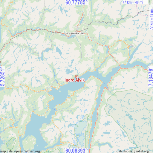
Indre Ålvik GPS coordinates[2]
60° 25' 57.864" North, 6° 25' 53.904" East
| Map corner | latitude | longitude |
|---|---|---|
| Upper-left | 60.77785°, | 5.72851° |
| Center: | 60.43274°, | 6.43164° |
| Lower-right: | 60.08393°, | 7.13476° |
| Map W x H: | 77.2×77.2 km | = 48×48mi |
| max Lat: | 71.04137° ⇑53.6% North |
| Indre Ålvik: | 60.43274° |
| min Lat: | ⇓46.4% South 58.0274° |
| min Long | Indre Ålvik | max Long |
| 4.71485° | 6.43164° | 31.11066° |
| W 20.9%⇐ | ⇒79.1% E |
Elevation
Elevation of Indre Ålvik is 35 m = 115 ft, and this is 69.2 m = 227 ft below average elevation for this country.
| Max E: |
897 m = 2943 ft | 54.7% |
| Avg. | 104.2 m = 342 ft | |
| Indre Ålvik | 35 m = 115 ft | |
Min E: |
1 m = 3 ft | 45.3% |
See also: Norway elevation on elevation.city.
Geographical zone
Indre Ålvik is located in North temperate zone (between Tropic of Cancer and the Arctic Circle). Distance of this North polar circle is 681.7 km =423.6 mi to North.| Distance of | km | miles | from Indre Ålvik |
|---|---|---|---|
| North Pole | 3287.6 | 2042.8 | to North |
| Arctic Circle | 681.7 | 423.6 | to North |
| Tropic Cancer | 4113.6 | 2556.1 | to South |
| Equator | 6719.5 | 4175.3 | to South |


Nearby cities:
15 places around Indre Ålvik: (largest is in red/bold)
• Dale
37.6 km =23.4 mi,  296°
296°
• Eidfjord
35.3 km =21.9 mi,  83°
83°
• Granvin
18.8 km =11.7 mi,  57°
57°
• Indra Haga
36.6 km =22.7 mi,  262°
262°
• Jondal
20.1 km =12.5 mi,  209°
209°
• Kinsarvik
17 km =10.6 mi,  111°
111°
• Lofthus
16.8 km =10.4 mi,  131°
131°
• Norheimsund
17.1 km =10.6 mi,  246°
246°
• Stanghelle
40.3 km =25 mi,  289°
289°
• Tysse
37.5 km =23.3 mi, 259°
• Tyssedal
35.9 km =22.3 mi,  168°
168°
• Ulvik
30.5 km =19 mi, 60°
• Vaksdal
38.2 km =23.7 mi,  277°
277°
• Voss
21.8 km =13.5 mi,  357°
357°
• Øystese
14 km =8.7 mi, 249°
Sources, notices
• [Note1] Compared only with cities in Norway existing in our database
• [Src1] Map data: © OpenStreetMap contributors (CC-BY-SA)
• [Src2] Other city data from geonames.org with taken over terms of usage.
• [Src3] Geographical zone / Annual Mean Temperature by Robert A. Rohde @ Wikipedia
