Jondal geodata
Jondal (Hordaland) is a seat of a second-order administrative division; located in Norway in Europe/Oslo (GMT+2) time zone. In our database, there are 488 cities with bigger population. Compared to other cities in Norway, 57.1% of cities are located further ↑North; 79.9% of cities are located further →East and 52.1% of cities have lower elevation than Jondal. Note1


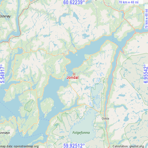
Jondal GPS coordinates[2]
60° 16' 32.196" North, 6° 15' 8.244" East
| Map corner | latitude | longitude |
|---|---|---|
| Upper-left | 60.62239°, | 5.54917° |
| Center: | 60.27561°, | 6.25229° |
| Lower-right: | 59.92512°, | 6.95542° |
| Map W x H: | 77.5×77.5 km | = 48.2×48.2mi |
| max Lat: | 71.04137° ⇑57.1% North |
| Jondal: | 60.27561° |
| min Lat: | ⇓42.9% South 58.0274° |
| min Long | Jondal | max Long |
| 4.71485° | 6.25229° | 31.11066° |
| W 20.1%⇐ | ⇒79.9% E |
Elevation
Elevation of Jondal is 48 m = 157 ft, and this is 56.2 m = 184 ft below average elevation for this country.
| Max E: |
897 m = 2943 ft | 47.9% |
| Avg. | 104.2 m = 342 ft | |
| Jondal | 48 m = 157 ft | |
Min E: |
1 m = 3 ft | 52.1% |
See also: Norway elevation on elevation.city.
Geographical zone
Jondal is located in North temperate zone (between Tropic of Cancer and the Arctic Circle). Distance of this North polar circle is 699.2 km =434.5 mi to North.| Distance of | km | miles | from Jondal |
|---|---|---|---|
| North Pole | 3305 | 2053.6 | to North |
| Arctic Circle | 699.2 | 434.5 | to North |
| Tropic Cancer | 4096.1 | 2545.2 | to South |
| Equator | 6702 | 4164.4 | to South |


Nearby cities:
15 places around Jondal: (largest is in red/bold)
• Eikelandsosen
28.3 km =17.6 mi,  262°
262°
• Granvin
37.7 km =23.4 mi,  42°
42°
• Indra Haga
29.3 km =18.2 mi,  295°
295°
• Indre Ålvik
20.1 km =12.5 mi,  29°
29°
• Kinsarvik
28 km =17.4 mi,  66°
66°
• Lofthus
23.4 km =14.5 mi, 74°
• Norheimsund
12.1 km =7.5 mi,  331°
331°
• Odda
28.1 km =17.5 mi,  144°
144°
• Rosendal
34.9 km =21.7 mi,  202°
202°
• Stanghelle
41.8 km =26 mi,  317°
317°
• Tysse
29.3 km =18.2 mi,  291°
291°
• Tyssedal
24.5 km =15.2 mi, 136°
• Vaksdal
35.9 km =22.3 mi,  308°
308°
• Voss
40.3 km =25 mi,  12°
12°
• Øystese
12.9 km =8 mi,  345°
345°
Sources, notices
• [Note1] Compared only with cities in Norway existing in our database
• [Src1] Map data: © OpenStreetMap contributors (CC-BY-SA)
• [Src2] Other city data from geonames.org with taken over terms of usage.
• [Src3] Geographical zone / Annual Mean Temperature by Robert A. Rohde @ Wikipedia
