Granvin geodata
Granvin (Hordaland) is a seat of a second-order administrative division; located in Norway in Europe/Oslo (GMT+2) time zone. With population of 460 people, there are 466 cities with bigger population in this country. Compared to other cities in Norway, 52.2% of cities are located further ↑North; 75.5% of cities are located further →East and 83.5% of cities have lower elevation than Granvin. Note1


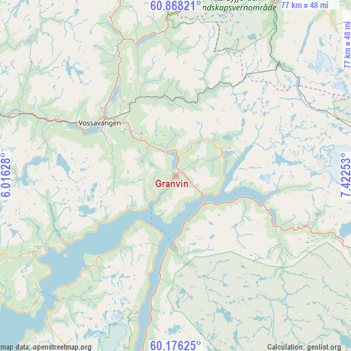
Granvin GPS coordinates[2]
60° 31' 26.688" North, 6° 43' 9.84" East
| Map corner | latitude | longitude |
|---|---|---|
| Upper-left | 60.86821°, | 6.01628° |
| Center: | 60.52408°, | 6.7194° |
| Lower-right: | 60.17625°, | 7.42253° |
| Map W x H: | 76.9×76.9 km | = 47.8×47.8mi |
| max Lat: | 71.04137° ⇑52.2% North |
| Granvin: | 60.52408° |
| min Lat: | ⇓47.8% South 58.0274° |
| min Long | Granvin | max Long |
| 4.71485° | 6.7194° | 31.11066° |
| W 24.5%⇐ | ⇒75.5% E |
Elevation
Elevation of Granvin is 200 m = 656 ft, and this is 95.8 m = 314 ft above average elevation for this country.
| Max E: |
897 m = 2943 ft | 16.5% |
| Granvin | 200 m 656 ft | |
| Avg. | 104.2 m = 342 ft | |
Min E: |
1 m = 3 ft | 83.5% |
See also: Norway elevation on elevation.city.
Geographical zone
Granvin is located in North temperate zone (between Tropic of Cancer and the Arctic Circle). Distance of this North polar circle is 671.5 km =417.3 mi to North.| Distance of | km | miles | from Granvin |
|---|---|---|---|
| North Pole | 3277.4 | 2036.5 | to North |
| Arctic Circle | 671.5 | 417.3 | to North |
| Tropic Cancer | 4123.7 | 2562.3 | to South |
| Equator | 6729.6 | 4181.6 | to South |


Nearby cities:
15 places around Granvin: (largest is in red/bold)
• Aurlandsvangen
49.5 km =30.8 mi,  30°
30°
• Dale
49.7 km =30.9 mi,  278°
278°
• Eidfjord
20.3 km =12.6 mi,  108°
108°
• Indre Ålvik
18.8 km =11.7 mi,  237°
237°
• Jondal
37.7 km =23.4 mi,  222°
222°
• Kinsarvik
16.5 km =10.3 mi,  179°
179°
• Lofthus
21.5 km =13.4 mi,  188°
188°
• Norheimsund
35.8 km =22.2 mi, 241°
• Odda
51.5 km =32 mi, 190°
• Stanghelle
53.9 km =33.5 mi,  273°
273°
• Tyssedal
46.2 km =28.7 mi, 191°
• Ulvik
11.8 km =7.3 mi,  65°
65°
• Vaksdal
53.8 km =33.4 mi,  264°
264°
• Voss
20.3 km =12.6 mi,  304°
304°
• Øystese
32.6 km =20.3 mi, 242°
Sources, notices
• [Note1] Compared only with cities in Norway existing in our database
• [Src1] Map data: © OpenStreetMap contributors (CC-BY-SA)
• [Src2] Other city data from geonames.org with taken over terms of usage.
• [Src3] Geographical zone / Annual Mean Temperature by Robert A. Rohde @ Wikipedia
