Vennesla geodata
Vennesla (Vest-Agder) is a seat of a second-order administrative division; located in Norway in Europe/Oslo (GMT+2) time zone. With population of 10,931 people, there are 46 cities with bigger population in this country. Compared to other cities in Norway, 97.3% of cities are located further ↑North; 67.4% of cities are located further →East and 53.3% of cities have lower elevation than Vennesla. Note1


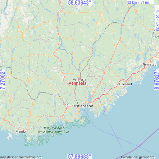
Vennesla GPS coordinates[2]
58° 16' 6.816" North, 7° 58' 23.304" East
| Map corner | latitude | longitude |
|---|---|---|
| Upper-left | 58.63643°, | 7.27002° |
| Center: | 58.26856°, | 7.97314° |
| Lower-right: | 57.89683°, | 8.67627° |
| Map W x H: | 82.2×82.2 km | = 51.1×51.1mi |
| max Lat: | 71.04137° ⇑97.3% North |
| Vennesla: | 58.26856° |
| min Lat: | ⇓2.7% South 58.0274° |
| min Long | Vennesla | max Long |
| 4.71485° | 7.97314° | 31.11066° |
| W 32.6%⇐ | ⇒67.4% E |
Elevation
Elevation of Vennesla is 53 m = 174 ft, and this is 51.2 m = 168 ft below average elevation for this country.
| Max E: |
897 m = 2943 ft | 46.7% |
| Avg. | 104.2 m = 342 ft | |
| Vennesla | 53 m = 174 ft | |
Min E: |
1 m = 3 ft | 53.3% |
See also: Norway elevation on elevation.city.
Geographical zone
Vennesla is located in North temperate zone (between Tropic of Cancer and the Arctic Circle). Distance of this North polar circle is 922.3 km =573.1 mi to North.| Distance of | km | miles | from Vennesla |
|---|---|---|---|
| North Pole | 3528.2 | 2192.3 | to North |
| Arctic Circle | 922.3 | 573.1 | to North |
| Tropic Cancer | 3872.9 | 2406.5 | to South |
| Equator | 6478.9 | 4025.8 | to South |


Nearby cities:
15 places around Vennesla: (largest is in red/bold)
• Birkeland
16.7 km =10.4 mi,  65°
65°
• Birketveit
21.4 km =13.3 mi,  351°
351°
• Evje
36.6 km =22.7 mi,  344°
344°
• Helland
27.6 km =17.1 mi,  252°
252°
• Jordtveit
31.2 km =19.4 mi,  89°
89°
• Justvik
8.7 km =5.4 mi,  156°
156°
• Konsmo
36.1 km =22.4 mi,  272°
272°
• Kristiansand
13.6 km =8.5 mi,  174°
174°
• Lillesand
23.8 km =14.8 mi,  95°
95°
• Nodeland
15 km =9.3 mi,  212°
212°
• Skålevik
21.2 km =13.2 mi, 173°
• Strai
9.2 km =5.7 mi,  196°
196°
• Søgne
22.5 km =14 mi, 209°
• Tangvall
21.1 km =13.1 mi, 205°
• Tveit
9.5 km =5.9 mi,  114°
114°
Sources, notices
• [Note1] Compared only with cities in Norway existing in our database
• [Src1] Map data: © OpenStreetMap contributors (CC-BY-SA)
• [Src2] Other city data from geonames.org with taken over terms of usage.
• [Src3] Geographical zone / Annual Mean Temperature by Robert A. Rohde @ Wikipedia
