Kjenn geodata
Kjenn (Akershus) is a seat of a second-order administrative division; located in Norway in Europe/Oslo (GMT+2) time zone. In our database, there are 488 cities with bigger population. Compared to other cities in Norway, 66.3% of cities are located further ↑North; 66.8% of cities are located further ←West and 82% of cities have lower elevation than Kjenn. Note1


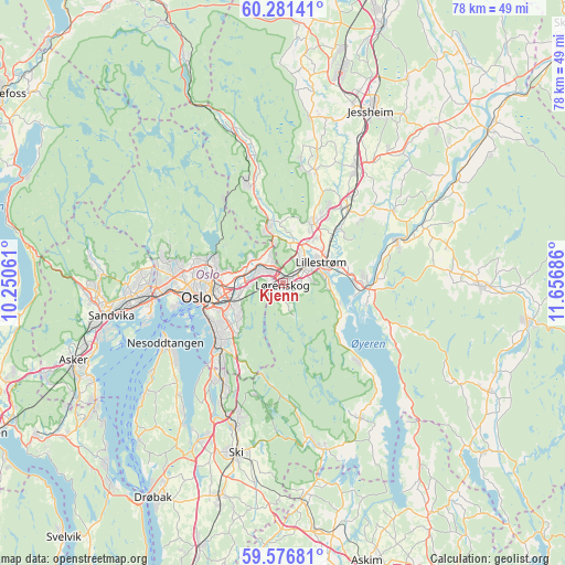
Kjenn GPS coordinates[2]
59° 55' 51.528" North, 10° 57' 13.428" East
| Map corner | latitude | longitude |
|---|---|---|
| Upper-left | 60.28141°, | 10.25061° |
| Center: | 59.93098°, | 10.95373° |
| Lower-right: | 59.57681°, | 11.65686° |
| Map W x H: | 78.3×78.3 km | = 48.7×48.7mi |
| max Lat: | 71.04137° ⇑66.3% North |
| Kjenn: | 59.93098° |
| min Lat: | ⇓33.7% South 58.0274° |
| min Long | Kjenn | max Long |
| 4.71485° | 10.95373° | 31.11066° |
| W 66.8%⇐ | ⇒33.2% E |
Elevation
Elevation of Kjenn is 181 m = 594 ft, and this is 76.8 m = 252 ft above average elevation for this country.
| Max E: |
897 m = 2943 ft | 18% |
| Kjenn | 181 m 594 ft | |
| Avg. | 104.2 m = 342 ft | |
Min E: |
1 m = 3 ft | 82% |
See also: Norway elevation on elevation.city.
Geographical zone
Kjenn is located in North temperate zone (between Tropic of Cancer and the Arctic Circle). Distance of this North polar circle is 737.5 km =458.3 mi to North.| Distance of | km | miles | from Kjenn |
|---|---|---|---|
| North Pole | 3343.4 | 2077.5 | to North |
| Arctic Circle | 737.5 | 458.3 | to North |
| Tropic Cancer | 4057.8 | 2521.4 | to South |
| Equator | 6663.7 | 4140.6 | to South |


Nearby cities:
15 places around Kjenn: (largest is in red/bold)
• Ask
16.3 km =10.1 mi,  16°
16°
• Fetsund
11.4 km =7.1 mi,  93°
93°
• Fjerdingby
6.2 km =3.9 mi, 94°
• Flateby
15.9 km =9.9 mi,  135°
135°
• Frogner
13.3 km =8.3 mi,  38°
38°
• Kolbotn
15.8 km =9.8 mi,  211°
211°
• Leirsund
10.4 km =6.5 mi,  45°
45°
• Lillestrøm
6 km =3.7 mi,  62°
62°
• Lindeberg
15.2 km =9.4 mi, 38°
• Lysaker
17.9 km =11.1 mi,  262°
262°
• Nesoddtangen
17.9 km =11.1 mi,  244°
244°
• Oslo
11.7 km =7.3 mi, 260°
• Rotnes
14.9 km =9.3 mi,  339°
339°
• Sjølyststranda
15.3 km =9.5 mi,  265°
265°
• Sørumsand
17.2 km =10.7 mi,  69°
69°
Sources, notices
• [Note1] Compared only with cities in Norway existing in our database
• [Src1] Map data: © OpenStreetMap contributors (CC-BY-SA)
• [Src2] Other city data from geonames.org with taken over terms of usage.
• [Src3] Geographical zone / Annual Mean Temperature by Robert A. Rohde @ Wikipedia
