Hansnes geodata
Hansnes (Troms) is a seat of a second-order administrative division; located in Norway in Europe/Oslo (GMT+2) time zone. With population of 342 people, there are 475 cities with bigger population in this country. Compared to other cities in Norway, 97.2% of cities are located further ↓South; 95.7% of cities are located further ←West and 100% of cities have higher elevation than Hansnes. Note1


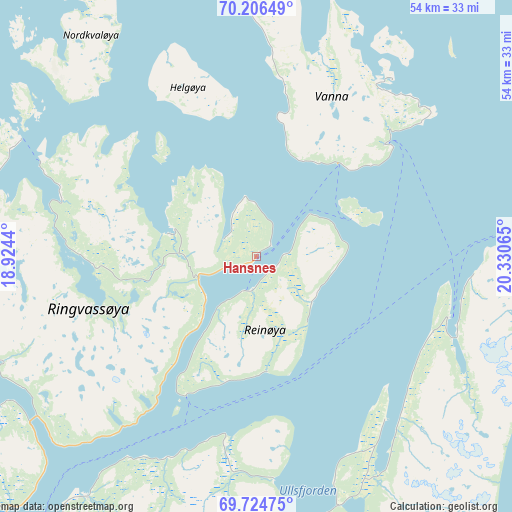
Hansnes GPS coordinates[2]
69° 58' 1.236" North, 19° 37' 39.072" East
| Map corner | latitude | longitude |
|---|---|---|
| Upper-left | 70.20649°, | 18.9244° |
| Center: | 69.96701°, | 19.62752° |
| Lower-right: | 69.72475°, | 20.33065° |
| Map W x H: | 53.6×53.6 km | = 33.3×33.3mi |
| max Lat: | 71.04137° ⇑2.8% North |
| Hansnes: | 69.96701° |
| min Lat: | ⇓97.2% South 58.0274° |
| min Long | Hansnes | max Long |
| 4.71485° | 19.62752° | 31.11066° |
| W 95.7%⇐ | ⇒4.3% E |
Elevation
Elevation of Hansnes is 1 m = 3 ft, and this is 103.2 m = 339 ft below average elevation for this country.
| Max E: |
897 m = 2943 ft | 100% |
| Avg. | 104.2 m = 342 ft | |
| Hansnes | 1 m = 3 ft | |
Min E: |
1 m = 3 ft | 0% |
See also: Norway elevation on elevation.city.
Geographical zone
Hansnes is located in North Frigid zone (between North Pole and Arctic Circle). Distance of this North polar circle is 378.4 km =235.1 mi to South.| Distance of | km | miles | from Hansnes |
|---|---|---|---|
| North Pole | 2227.5 | 1384.1 | to North |
| Arctic Circle | 378.4 | 235.1 | to South |
| Tropic Cancer | 5173.7 | 3214.8 | to South |
| Equator | 7779.6 | 4834 | to South |


Nearby cities:
15 places around Hansnes: (largest is in red/bold)
• Andselv
109.2 km =67.9 mi,  203°
203°
• Burfjord
92.5 km =57.5 mi,  91°
91°
• Finnsnes
103.9 km =64.6 mi,  217°
217°
• Hatteng
78.5 km =48.8 mi,  170°
170°
• Lyngseidet
49 km =30.4 mi,  152°
152°
• Moen
101 km =62.8 mi, 202°
• Olderdalen
53.3 km =33.1 mi,  139°
139°
• Skaland
107 km =66.5 mi,  237°
237°
• Skjervøy
51.6 km =32.1 mi,  82°
82°
• Storslett
57.9 km =36 mi,  112°
112°
• Storsteinnes
82.2 km =51.1 mi,  190°
190°
• Sørreisa
107.8 km =67 mi,  212°
212°
• Tromsø
43.8 km =27.2 mi, 216°
• Vangsvika
115.1 km =71.5 mi, 219°
• Øksfjord
107.4 km =66.7 mi,  73°
73°
Sources, notices
• [Note1] Compared only with cities in Norway existing in our database
• [Src1] Map data: © OpenStreetMap contributors (CC-BY-SA)
• [Src2] Other city data from geonames.org with taken over terms of usage.
• [Src3] Geographical zone / Annual Mean Temperature by Robert A. Rohde @ Wikipedia
