Sørreisa geodata
Sørreisa (Troms) is a seat of a second-order administrative division; located in Norway in Europe/Oslo (GMT+2) time zone. In our database, there are 488 cities with bigger population. Compared to other cities in Norway, 94.6% of cities are located further ↓South; 94.8% of cities are located further ←West and 75.8% of cities have higher elevation than Sørreisa. Note1


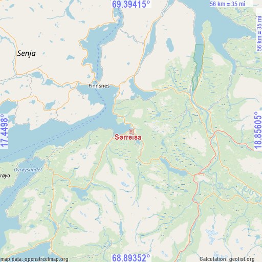
Sørreisa GPS coordinates[2]
69° 8' 42.972" North, 18° 9' 10.512" East
| Map corner | latitude | longitude |
|---|---|---|
| Upper-left | 69.39415°, | 17.4498° |
| Center: | 69.14527°, | 18.15292° |
| Lower-right: | 68.89352°, | 18.85605° |
| Map W x H: | 55.7×55.7 km | = 34.6×34.6mi |
| max Lat: | 71.04137° ⇑5.4% North |
| Sørreisa: | 69.14527° |
| min Lat: | ⇓94.6% South 58.0274° |
| min Long | Sørreisa | max Long |
| 4.71485° | 18.15292° | 31.11066° |
| W 94.8%⇐ | ⇒5.2% E |
Elevation
Elevation of Sørreisa is 13 m = 43 ft, and this is 91.2 m = 299 ft below average elevation for this country.
| Max E: |
897 m = 2943 ft | 75.8% |
| Avg. | 104.2 m = 342 ft | |
| Sørreisa | 13 m = 43 ft | |
Min E: |
1 m = 3 ft | 24.2% |
See also: Norway elevation on elevation.city.
Geographical zone
Sørreisa is located in North Frigid zone (between North Pole and Arctic Circle). Distance of this North polar circle is 287.1 km =178.4 mi to South.| Distance of | km | miles | from Sørreisa |
|---|---|---|---|
| North Pole | 2318.8 | 1440.8 | to North |
| Arctic Circle | 287.1 | 178.4 | to South |
| Tropic Cancer | 5082.3 | 3158 | to South |
| Equator | 7688.2 | 4777.2 | to South |


Nearby cities:
15 places around Sørreisa: (largest is in red/bold)
• Andselv
16.9 km =10.5 mi,  121°
121°
• Bjerkvik
70.5 km =43.8 mi,  199°
199°
• Brøstadbotn
19.2 km =11.9 mi,  250°
250°
• Finnsnes
11.6 km =7.2 mi,  324°
324°
• Gratangen
58.2 km =36.2 mi, 198°
• Gryllefjord
49.6 km =30.8 mi,  299°
299°
• Hamnvik
56.5 km =35.1 mi,  223°
223°
• Moen
18.3 km =11.4 mi,  95°
95°
• Setermoen
32.6 km =20.3 mi,  166°
166°
• Sjøvegan
32.6 km =20.3 mi, 201°
• Skaland
47.3 km =29.4 mi,  314°
314°
• Storsteinnes
44 km =27.3 mi,  76°
76°
• Tennevoll
46.4 km =28.8 mi, 197°
• Tromsø
64.2 km =39.9 mi,  29°
29°
• Vangsvika
16.8 km =10.4 mi,  279°
279°
Sources, notices
• [Note1] Compared only with cities in Norway existing in our database
• [Src1] Map data: © OpenStreetMap contributors (CC-BY-SA)
• [Src2] Other city data from geonames.org with taken over terms of usage.
• [Src3] Geographical zone / Annual Mean Temperature by Robert A. Rohde @ Wikipedia
