Storsteinnes geodata
Storsteinnes (Troms) is a seat of a second-order administrative division; located in Norway in Europe/Oslo (GMT+2) time zone. With population of 890 people, there are 338 cities with bigger population in this country. Compared to other cities in Norway, 95.1% of cities are located further ↓South; 95.6% of cities are located further ←West and 100% of cities have higher elevation than Storsteinnes. Note1


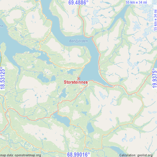
Storsteinnes GPS coordinates[2]
69° 14' 26.916" North, 19° 14' 3.732" East
| Map corner | latitude | longitude |
|---|---|---|
| Upper-left | 69.4886°, | 18.53125° |
| Center: | 69.24081°, | 19.23437° |
| Lower-right: | 68.99016°, | 19.9375° |
| Map W x H: | 55.4×55.4 km | = 34.4×34.4mi |
| max Lat: | 71.04137° ⇑4.9% North |
| Storsteinnes: | 69.24081° |
| min Lat: | ⇓95.1% South 58.0274° |
| min Long | Storsteinnes | max Long |
| 4.71485° | 19.23437° | 31.11066° |
| W 95.6%⇐ | ⇒4.4% E |
Elevation
Elevation of Storsteinnes is 1 m = 3 ft, and this is 103.2 m = 339 ft below average elevation for this country.
| Max E: |
897 m = 2943 ft | 100% |
| Avg. | 104.2 m = 342 ft | |
| Storsteinnes | 1 m = 3 ft | |
Min E: |
1 m = 3 ft | 0% |
See also: Norway elevation on elevation.city.
Geographical zone
Storsteinnes is located in North Frigid zone (between North Pole and Arctic Circle). Distance of this North polar circle is 297.7 km =185 mi to South.| Distance of | km | miles | from Storsteinnes |
|---|---|---|---|
| North Pole | 2308.2 | 1434.2 | to North |
| Arctic Circle | 297.7 | 185 | to South |
| Tropic Cancer | 5092.9 | 3164.6 | to South |
| Equator | 7698.9 | 4783.9 | to South |


Nearby cities:
15 places around Storsteinnes: (largest is in red/bold)
• Andselv
34.5 km =21.4 mi,  235°
235°
• Brøstadbotn
63.2 km =39.3 mi,  254°
254°
• Finnsnes
49.4 km =30.7 mi,  268°
268°
• Hansnes
82.2 km =51.1 mi,  10°
10°
• Hatteng
28.7 km =17.8 mi,  83°
83°
• Lyngseidet
53.6 km =33.3 mi,  45°
45°
• Moen
27.5 km =17.1 mi, 243°
• Olderdalen
64.9 km =40.3 mi, 51°
• Setermoen
55 km =34.2 mi,  219°
219°
• Sjøvegan
68.6 km =42.6 mi,  233°
233°
• Skaland
79.2 km =49.2 mi,  286°
286°
• Sørreisa
44 km =27.3 mi,  256°
256°
• Tennevoll
79.1 km =49.2 mi, 226°
• Tromsø
46.7 km =29 mi,  346°
346°
• Vangsvika
59.7 km =37.1 mi, 262°
Sources, notices
• [Note1] Compared only with cities in Norway existing in our database
• [Src1] Map data: © OpenStreetMap contributors (CC-BY-SA)
• [Src2] Other city data from geonames.org with taken over terms of usage.
• [Src3] Geographical zone / Annual Mean Temperature by Robert A. Rohde @ Wikipedia
