Hatteng geodata
Hatteng (Troms) is a seat of a second-order administrative division; located in Norway in Europe/Oslo (GMT+2) time zone. In our database, there are 488 cities with bigger population. Compared to other cities in Norway, 95.3% of cities are located further ↓South; 95.9% of cities are located further ←West and 60.4% of cities have lower elevation than Hatteng. Note1


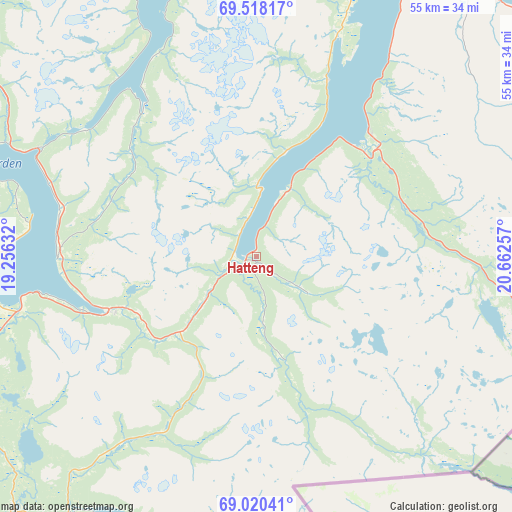
Hatteng GPS coordinates[2]
69° 16' 14.592" North, 19° 57' 33.984" East
| Map corner | latitude | longitude |
|---|---|---|
| Upper-left | 69.51817°, | 19.25632° |
| Center: | 69.27072°, | 19.95944° |
| Lower-right: | 69.02041°, | 20.66257° |
| Map W x H: | 55.3×55.3 km | = 34.4×34.4mi |
| max Lat: | 71.04137° ⇑4.7% North |
| Hatteng: | 69.27072° |
| min Lat: | ⇓95.3% South 58.0274° |
| min Long | Hatteng | max Long |
| 4.71485° | 19.95944° | 31.11066° |
| W 95.9%⇐ | ⇒4.1% E |
Elevation
Elevation of Hatteng is 68 m = 223 ft, and this is 36.2 m = 119 ft below average elevation for this country.
| Max E: |
897 m = 2943 ft | 39.6% |
| Avg. | 104.2 m = 342 ft | |
| Hatteng | 68 m = 223 ft | |
Min E: |
1 m = 3 ft | 60.4% |
See also: Norway elevation on elevation.city.
Geographical zone
Hatteng is located in North Frigid zone (between North Pole and Arctic Circle). Distance of this North polar circle is 301 km =187 mi to South.| Distance of | km | miles | from Hatteng |
|---|---|---|---|
| North Pole | 2304.9 | 1432.2 | to North |
| Arctic Circle | 301 | 187 | to South |
| Tropic Cancer | 5096.3 | 3166.7 | to South |
| Equator | 7702.2 | 4785.9 | to South |


Nearby cities:
15 places around Hatteng: (largest is in red/bold)
• Andselv
61.5 km =38.2 mi,  248°
248°
• Brøstadbotn
91.8 km =57 mi,  257°
257°
• Finnsnes
78.1 km =48.5 mi,  266°
266°
• Hansnes
78.5 km =48.8 mi,  350°
350°
• Lyngseidet
35.5 km =22.1 mi,  16°
16°
• Moen
55.4 km =34.4 mi, 253°
• Olderdalen
43.3 km =26.9 mi,  31°
31°
• Setermoen
78.6 km =48.8 mi,  234°
234°
• Sjøvegan
94.8 km =58.9 mi,  242°
242°
• Skjervøy
93.2 km =57.9 mi, 24°
• Storslett
69.1 km =42.9 mi,  36°
36°
• Storsteinnes
28.7 km =17.8 mi, 263°
• Sørreisa
72.7 km =45.2 mi, 258°
• Tromsø
57.5 km =35.7 mi,  317°
317°
• Vangsvika
88.5 km =55 mi, 262°
Sources, notices
• [Note1] Compared only with cities in Norway existing in our database
• [Src1] Map data: © OpenStreetMap contributors (CC-BY-SA)
• [Src2] Other city data from geonames.org with taken over terms of usage.
• [Src3] Geographical zone / Annual Mean Temperature by Robert A. Rohde @ Wikipedia
