Olderdalen geodata
Olderdalen (Troms) is a seat of a second-order administrative division; located in Norway in Europe/Oslo (GMT+2) time zone. With population of 312 people, there are 481 cities with bigger population in this country. Compared to other cities in Norway, 96.2% of cities are located further ↓South; 96.2% of cities are located further ←West and 58.7% of cities have higher elevation than Olderdalen. Note1


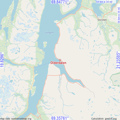
Olderdalen GPS coordinates[2]
69° 36' 14.652" North, 20° 31' 57.792" East
| Map corner | latitude | longitude |
|---|---|---|
| Upper-left | 69.84771°, | 19.8296° |
| Center: | 69.60407°, | 20.53272° |
| Lower-right: | 69.35761°, | 21.23585° |
| Map W x H: | 54.5×54.5 km | = 33.9×33.9mi |
| max Lat: | 71.04137° ⇑3.8% North |
| Olderdalen: | 69.60407° |
| min Lat: | ⇓96.2% South 58.0274° |
| min Long | Olderdalen | max Long |
| 4.71485° | 20.53272° | 31.11066° |
| W 96.2%⇐ | ⇒3.8% E |
Elevation
Elevation of Olderdalen is 29 m = 95 ft, and this is 75.2 m = 247 ft below average elevation for this country.
| Max E: |
897 m = 2943 ft | 58.7% |
| Avg. | 104.2 m = 342 ft | |
| Olderdalen | 29 m = 95 ft | |
Min E: |
1 m = 3 ft | 41.3% |
See also: Norway elevation on elevation.city.
Geographical zone
Olderdalen is located in North Frigid zone (between North Pole and Arctic Circle). Distance of this North polar circle is 338.1 km =210.1 mi to South.| Distance of | km | miles | from Olderdalen |
|---|---|---|---|
| North Pole | 2267.8 | 1409.1 | to North |
| Arctic Circle | 338.1 | 210.1 | to South |
| Tropic Cancer | 5133.3 | 3189.7 | to South |
| Equator | 7739.2 | 4808.9 | to South |


Nearby cities:
15 places around Olderdalen: (largest is in red/bold)
• Alta
112.8 km =70.1 mi,  68°
68°
• Andselv
99.2 km =61.6 mi,  232°
232°
• Burfjord
69.2 km =43 mi,  57°
57°
• Finnsnes
108.1 km =67.2 mi,  247°
247°
• Hansnes
53.3 km =33.1 mi,  319°
319°
• Hatteng
43.3 km =26.9 mi,  211°
211°
• Kautokeino
118.5 km =73.6 mi,  123°
123°
• Lyngseidet
12.6 km =7.8 mi,  255°
255°
• Moen
91.8 km =57 mi,  235°
235°
• Skjervøy
50.4 km =31.3 mi,  19°
19°
• Storslett
26.3 km =16.3 mi,  46°
46°
• Storsteinnes
64.9 km =40.3 mi, 231°
• Sørreisa
106.2 km =66 mi, 241°
• Tromsø
61.3 km =38.1 mi,  274°
274°
• Øksfjord
99 km =61.5 mi,  44°
44°
Sources, notices
• [Note1] Compared only with cities in Norway existing in our database
• [Src1] Map data: © OpenStreetMap contributors (CC-BY-SA)
• [Src2] Other city data from geonames.org with taken over terms of usage.
• [Src3] Geographical zone / Annual Mean Temperature by Robert A. Rohde @ Wikipedia
